|
Parish 19 |
Date of Agreement / Award |
Date of Confirmation of Apportionment |
Batcombe |
23/2/1839 |
31/3/1841 |
|
Date on Map |
Scale of Map |
Signed |
|
1838 |
3 chains |
John Martin of Evershot in the County of Dorset -Valuer |
The power of the church is often forgotten but anciently Batcombe or Badecomb [together with Melbury Bubb and Osmond, Leigh, Stockwood and Yetminster] belonged to the Bishop of Sarum [Salisbury]. In 1548 it was sold and in 1598 it was granted to Sir Walter Raleigh. It did not appear in Domesday so was either not surveyed or was held under a different name.
The parish consisted of a number of dispersed farmsteads and lay at the edge of the Vale of Blackmore, or as Hardy called it the Vale of Little Dairies. The southeastern and southwestern sides of the parish rose steeply to the chalk plateau above that filled most of central Dorset.
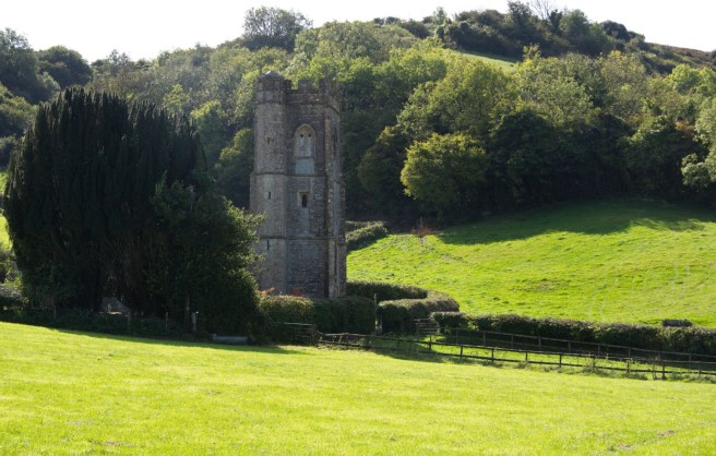
Batcombe church nestles in the woods below what was once the East Down. The land rises slowly from about 50m at Sherborne to 130m at Batcombe village before almost doubling it’s height to reach the chalk plateau that surrounded the village on two sides. A power cable runs across the original which has been cloned out. In 1840 a barn belonging to the Rector lay between the hedge and the fence.

In the other direction the church faces the west down. In Martin’s time both downs were common land.
The church, which is not displayed pictorially on the map, was rebuilt in 1864, and the later layout differs from that on the map. Behind the church in the upper picture is what is labelled on the map, the east down and in the lower church it is backed by the west down.
The hazards attendant on the commutation process are demonstrated at Batcombe. The maps are drawn to a scale of three chains but there are no construction lines on the original map and it does not appear that it was intended to be a first class map. The original map bears the endorsement that it was adopted on the 24th December 1838 but it has been heavily cropped and there are no signatures on it. The agreement is dated February 1839.
The map has some interesting features. Of historic interest, towards the bottom right of the map is a depiction of the Cross Hand stone. This stone which is about three foot six inches tall, cylindrical with a bulbous end is mentioned in Thomas Hardy’s novel Tess of the d’Urbevilles when the villain of the peace, having first seduced her makes Tess swear on the stone that she would never tempt him again.
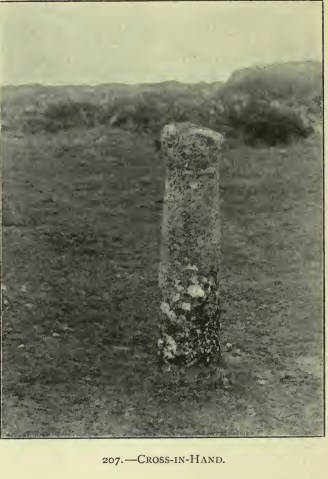
Today the stone has been surrounded by a low fence and is considerably less open than in this picture. From Hermann Lea Thomas Hardy’s Wessex 1913.
The main settlement in the parish is clustered around a triangular area of land bounded by roads. Nothing remarkable there but instead of the centre of the village green being grassland it is divided up into an orchard and an area labelled “Pleck”[1] which was the waste land. The pound is attached to this. On the original map this has little dots on the inside of it but the copy map is plain.
The instrument of apportionment starts conventionally enough with an agreement between the landowners and the rector the Revd. Samuel Lane dated third of October 1837 and confirmed by the commission on 23rd February 1839. This is unusual in itself as a delay of almost eighteen months between agreement and confirmation of the agreement seems remarkably long. The Revd. Lane was awarded one hundred and thirty nine pounds. The first entry concerning Batcombe in the diaries is from March 1838 and in April Martin began surveying. As he paid 8s to a Mrs Guppy in September for Mr Pines lodgings, we may assume that Pine was helping him measure the parish. This is Mrs Winifred Guppy aged 65 who was living with her grandson Thomas aged 15 in Batcombe in 1841. She is not listed as an occupier on the tithe map and her designation in the census of 1841 is ‘pauper’. She may have been resident in the parish poor house which would surely have been an interesting experience for Mr Pyne.
At some time however a problem arose as page three of the instrument of apportionment begins “And whereas a separate Award by way of Supplement to the foregoing Parochial Agreement was on the Nineteenth day of September in the year one thousand eight hundred and forty confirmed by the said Commissioners of which Award the following is a copy”.
This part of the “separate award” appears to have been written by Martin [it was an acknowledged copy] even though the original had been made by Aneurin Owen the ATC. It recites that although the agreement had been confirmed by the Tithe Commission the apportionment of the rent charge hadn’t. This was a technical point it simply meant that the commutation hadn’t been yet written into law and was thus still open to appeal.
A complaint had been received that “an error has been committed in the said Agreement by including the Tithes arising from certain Lands in the Parish of Leigh”. Who made this complaint is not known but after making investigations and holding parochial meetings, Owen had determined that “certain enclosures containing by admeasurement Eighty acres three roods and twenty five perches statute measure” were indeed in the neighbouring parish of Leigh. He ordered that that said eighty acres and the rent-charge attaching to them “be expunged from the said apportionment and accompanying map” with the consequence that seven pounds nineteen shillings and six pence was deducted from the Revd. Lane’s rent-charge.
By the time that the mistake was recognised Martin had already apportioned the land, made the map [which was adopted by the landowners on the 24th December 1838] and allocated plot numbers to all of the parcels of land in what was supposed to be the whole parish. These plot numbers and details of the fields are listed in the award but the plot numbers were not written onto either the original or copy map. Either they had not been put on the map in the first place or they had literally been erased from it. Both the original and the copy maps have been endorsed with “IN THE PARISH OF LEIGH” in those closes affected together in one area with “IN THE PARISH OF HILLFIELD”. This latter does not appear to have been a problem.
How had the mistake arisen? Who was to blame? We do not know. The agreement between the landowners and Rector had been made in 1837, in theory before Martin had been involved. It would have been mutually agreed on the basis of the average of the previous seven years tithe payments that the farmers of Batcombe had paid to the Rector of Batcombe. Whether the tithe had been paid in kind, or as a monetary composition, a part of it must have been raised on the eighty acres that was now found to be in the parish of Leigh.[2]
The eighty acres was divided up between eleven different owners, including the Countess of Sandwich and the Earl of Darlington, and none of them had other land in Leigh. It seems incredible that neither the landowners or the rector new the exact bounds of Batcombe and it is highly likely that the predecessors of those landowners had paid the predecessors of the Rector that part of the tithe for generations beforehand. How long for is again unknowable.
What we do know is that the matter was almost certainly brought to light when the commutations took place in Yetminster. As mentioned above Yetminster, Leigh and Batcombe had all belonged to the Bishop of Sarum at one time. On the 30th June 1840 Aneurin Owen made an award at Yetminster [he was a busy man that summer] and noted that the tithes of Yetminster had once been owned by the Prepend of the Prebendary of Yetminster and Grimston in the Cathedral Church of Sarum. However this prebendary had lapsed and the ownership of the tithe had passed to the Treasurer of Queen Anne’s Bounty.
The Bounty had been established in 1704 by Anne to supplement the poorest of livings by the restoration of what were known as the first fruits and tenths to the church. This was in a sense a clerical tithe as the Clergy were supposed to pay a portion of their first years income [after induction into the parish] and a tenth of their revenue thereafter. Unfortunately the Bounty was usually short of money:“The main reason for the large arrears was the reluctance of the clergy to pay their First Fruits and Tenths. Bishops were not always good examples to their clergy in this respect”.[3]
After his time in Yetminster, Aneurin Owen moved on to Leigh and made an award there on the 31st August 1840. In fact Leigh was not a parish at all but an outpost or Chapelry of the “Tithing of Yetminster in the Parish of Yetminster”. Leigh was surveyed for the commutation in 1840 and the man that did that was Martin’s old friend Edward Watts. It is probably not a coincidence that Owen was called in to both places; it is highly likely [although not stated] that the person to initiate the appeal over the tithes at Batcombe was the Treasurer of Queen Ann’s bounty who would have been keen to maximise the earnings of that organisation and alert to the possibility of some irregularity.
The award at Batcombe was made on the usual basis that the previous seven years average value “would not fairly represent the sum which ought to be the basis for a permanent commutation of the said tithes” the reason being given that “certain inclosures containing by admeasurement eighty acres three roods and twenty five perches….are admitted to be in the Parish of Leigh”.
Was Martin to blame in any way? The surveyors had some responsibility in defining the boundaries of the parish, as Dawson had made clear in his instructions to surveyors: when using a map supplied by the landowners they had “To test the accuracy of any such plan which may be found, giving particular attention to the external boundary of the parish, in order to guard against any contradiction or in consistency in the position of the boundary lines, as compared with those of the adjoining parishes which are to be surveyed for the same purposes”.
Without the evidence that was brought forward it is difficult to say what he could have done given the circumstances. The landowners had already approved the map and it must have been the case that they and the rector believed these eighty acres to be in Batcombe. What reason would Martin have to doubt the map and its boundaries?
In the end however the “parochial boundaries must be determined by the Commissioners” as Dawson had foreseen and the 1837 Tithe Amendment Act granted them additional powers. If two thirds “by number and value of the landowners of the parishes or townships affected by the dispute” applied to the Commission they could “set out the ancient boundaries, or define a new line of boundary”. Somebody in Leigh must known that the lands were not in Batcombe, but who? We will never know. Doubtless it made little difference to the landowners who they paid the rent-charge to. Had their been a major difference in the moduses between parishes, an advantage might have been gained but that does not appear to have been the case here. The only person to lose out was the Vicar the Revd. Samuel Lane. He may not have been too pleased when he next met his counterpart in Leigh who had deprived him of seven pounds nineteen shillings and sixpence.
The diary entries regarding Batcombe are unremarkable and reference to the chain men and the fact that Mr Pine had attended suggests that the parish was surveyed.The apportionment was slightly out of the ordinary as both down were used for common pasture with twelve owners being allowed to graze between them 111 cows and 1270 sheep. The rights of common varied considerably with no obvious correlation the number of cattle and sheep that could be grazed. Common rights of course had a value and a part of the rent charge Martin indicates was distributed on the basis of the value of these rights although needless to say we don’t know how.
Finally the entry for 6th September indicates that Martin was also taking the opportunity to combine the tithe commutation with the poor rate assessment.
| 20th March 1838 | Sent Mr Tooks of Sherborne my Office Copy of Particulars of Bincombe and went to Batcombe £1 1s 0d in the afternoon |
| 21st March 1838 | Pasting Paper for Maps & went to Batcombe |
| 2nd April 1838 | Paid Chain Man at Batcombe £1 12s 6d” |
| April in Accounts | Paid More for Chain Man at Batcombe |
| 5th June 1838 | Valuing at Batcombe |
| 6th June 1838 | Valuing at Batcombe Edwin affixed second notice of Tithe Meeting to the Maiden Newton Church Door |
| 9th August 1838 | Mr Banger working upon the same [Witherstone commutation] all the Morning and returned home and went to Batcombe the afternoon [sic] resp rate. |
| 15th August 1838 | Went to Batcombe with Notice for meeting to produce Map |
| 31st August 1838 | Working on Batcombe Tithes |
| 4th September 1838 | Working on Batcombe and From Vauchurch Rent charges &c |
| 6th September 1838 | Attending at Batcombe the whole of the day respecting Poors Rate |
| 7th September 1838 | Altering the Batcombe Rate and working on Downfrome Rent charges |
| 8th September 1838 | Working on Downfrome and Batcombe Rent Charges |
| 10th September 1838 | Working on Batcombe and Downfrome apportionment |
| 17th September 1838 Accounts | Pd Mrs Guppy of Batcombe for Mr Pines Lodging 8s |
| 17th December 1838 | Pasting Paper and doing Various Jobs and looking over the Batcombe Rent Charge |
| 24th December 1838 | Batcombe attending a Vestry to have the Map adopted |
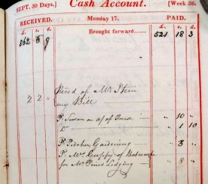
Finally there is a payment from the Revd. Sam Lane in 1845. Why he should being paid so late is a mystery as is what he is being paid for. The expenses of commutation were normally borne by the landowners.
| January 1845 | Received of the Rev Sam Lane Batcombe Com Rate £10 6s 6d |
1 Old English ‘a small piece of land’.
2 Otherwise the agreed amount of £139 would not have been reduced.
3 Queen Anne Bounty Tercentenary Booklet. J Aker.
