This inclosure was of the commons and waste in Rampisham together with a small area of land in West Chelborough. The open fields had been inclosed in the past – date unknown. In fact it is difficult to know precisely where the open fields were in the parish. There are a number of small strip like inclosures in the north east of the parish which indicate where the open fields may have lain but it’s difficult to believe they were ever extensive.
The manor as we have seen in the section on the Manor had been bought in 1812 by John Daniell, but it is apparent that Daniell owned land in the manor long before he bought the manor. In 1807 he commissioned a survey of the leasehold lands that he owned there and he chose Edward Watts a surveyor from Yeovil.
For those who enjoy maps those drawn by Watts are exquisite and worthy of mention. For his survey in 1807 he produced two that have survived, one on vellum and the other on cloth which I take to be linen. It is not possible today to know what these maps looked like when they were first produced but that drawn on vellum is rather muted with pastel colours and clear, but not over sharp text [below left]. In contrast that on the right is on linen and is much sharper with colours that are as vivid as the day it was made [probably!]


This is Mr Watts’s linen map and it shows extensive areas of common, almost indeed as much as the cultivated lands. One of the reason that the waste or common survived for so long is that until the mid 18th century the population of England was probably no more than 5 million and was virtually static. There was simply more land available than could be cultivated by the available population.
It is clear that Rampisham Hill has been significantly encroached upon in the past although it is not possible to say when. One of the reasons that the inclosure movement gained traction was as much the growth in population as it was the need to provide more food during the period of the French wars. The commons are so extensive that it is difficult see where the old open fields once lay but there may have been one field near Mark Common

The area near Mark Common shows numerous small inclosed closes, the only real indication there were ever open fields at Rampisham
The pictures do not do the linen map full justice. They have not been enhanced digitally but the colours are much cleaner and the text crisp and sharp compared to the map on vellum. You can also just make out the woven nature of the linen drawn map. Incredible to think that it is over two hundred years old.

Made over two hundred years ago the images of this map have not needed any digital ‘enhancement’.
The craftsmanship is truly astonishing as witnessed by the detailing of the church. The scale may be judged by the adjacent pencil tip. The Dorset historic churches trust [1] recounts that the church was rebuilt in 1858 when the belfry was added. Watts’ map indicates that there was one already there in 1807.
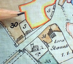

Even the legend and the cartouche are thinks of beauty, well in my eyes at least.
As well as the map it is lucky that Watts’ book of particulars has survived. One curiosity is that he quotes areas in both customary and statute acres.

It can be seen that customary areas were always larger than the statute acre. Prior to the introduction of measurement by chain it was customary to use a deal rod to measure the land. For statute acres the length was set at 16.5 feet [5 ½ yards] but many counties, even on occasions individual towns such as Yeovil, did their own thing and used rods of a different lengths. Using a longer rod would result in a customary area which is greater than the statute acre. On the figures given, without the fence, the average area of the customary acre shows considerable variation being between 17 and 24% bigger than the statute acre. [2] In Hampshire a rod of 5 yards was not unknown whereas in Lancashire it could be a whopping 8 ½ yards.[3] The use of customary acres was dying out, and inclosures had to be measured using statute acres, but presumably Watt’s felt it wise to have both measures to satisfy those proprietors who may have wondered why their land had apparently shrunk.

The opening page of the Commissioners minute book.
The Act for “Inclosing Lands within the Manor of Rampisham in the Parishes of Rampisham and West Chelborough” was passed in 1813 and the land to be inclosed under the Act was “certain commons and waste land, containing about eight hundred acres”. The Martin family archive, now at the Dorset History Centre, has Martin’s personal copy of the act from which the following is taken. It is typical of so many private acts for inclosure that it is worth considering it in some detail.
The Act notes that “the Right Honourable Henry Stawell Bilson Legge Lord Stawell and John Daniell Esquire, are Lords of the said manor” and that being landowners within the said manor “they are entitled to common of pasture in over and upon the same commons and waste lands.” Lord Stawell, William Bentham and George Kinderley of Lincoln’s Inn are the patrons of the rectory and the Reverend William Pace was the current rector. The reasons for undertaking the inclosure are given “whereas the said commons and waste lands are in their present state and condition incapable of any material improvement, and the several persons interested in the said commons and waste lands as aforesaid are desirous that the same should be divided and inclosed and specific parts thereof allotted to them respectively in proportion to their respective rights and interests therein..”
George Barnes of Andover, William Jennings, and John Edge were appointed as commissioners with the appropriate authority being given them to undertake the inclosure and also to remove or replace one of the others if they “shall die, or shall refuse, neglect or become incapable to act”. They are to hold meetings for the execution of the act and the first three of these are to be advertised in the press and a notice attached to the door of the church. No meeting was to take place more than eight miles from the parish. All in all fairly standard conditions.
“James Dean of Heavitree in the county of Devon, land-surveyor” was appointed surveyor to the inclosure. George Barnes and William Jennings are referred to in the act as surveyors and it is not known if the addition of ‘land’ to James Deans title is in anyway significant. There is a clause that he can be removed if needs be for the same reasons as the commissioner; in the event this would prove to be necessary. The commissioners were paid three guineas a day whilst employed in the execution of the act and could pay the clerk to the act ,John Jennings, and the surveyor “such sum or recompence [sic] as the said commissioners shall think just and reasonable.”
It is clear that a part of the common had already been inclosed for there is a specific clause in the act that forbids these from being a part of the inclosure process. On Watts’ map these lands lay in the south west part of the manor. Some of these old inclosures had been undertaken with the “express consent, written or unwritten of the homage [4] of the said manor” but the clause also forbids inclosure of any “encroachment which shall have been made and continued from or upon the said commons or waste lands…for forty years upwards antecedent to the passing of the act”. Illegal inclosures of the common were not unusual, some are mentioned in the court roll of Rampisham previously referred to. This clause gave protection to some people at least who, if not legally commoners, had at least, by virtue of time, acquired some right of occupation on the common. Forty years is of course a long time and difficult to prove and how much protection the clause afforded is open to doubt; it was precisely the issue of encroachment on the common that gave problems at Kingsclere [infra vide] where the time allowed was much less – twenty years. The next clause however makes it clear that if the encroachment was less than forty years the land would be included in the inclosure and presumably meant the ejection of any.
Another clause authorised the commissioners to allot land for stone or gravel pits to be used by the “occupiers of estates in the parish” but the ground soil and herbage of such land was to remain in the ownership of the Lords of the manor – which was in any case their traditional right.
When it comes to the allocation of lands it is of note that the very first clause to deal with this subject is the allocation of land to the Rector who would receive “such allotment or allotments [quantity, quality and situation considered]” that “shall be fair and reasonable” and it is clearly intended that this land be sufficient to allow for the remaining inclosed land to be tithe free although interestingly the exact proportion to be allowed is not specified. The rectors lands also had to be fenced at the expense of those proposing the inclosure- a common enough clause.
The Commissioners were given discretion to award the Lords land “as a compensation for and according to their respective rights and interests in the soil of the commons and waste lands” but the amount or percentage was not specified.
The residue of the common after the rights of the lords of the manor were taken into account were to be divided amongst those with rights of pasture in the common; those rights to be determined by the commissioners. In practice this would have been the customary tenants – the copyholders or those lease holders who held for a number of lives. One group who were denied any allotments were those who leased land at ‘rack’ rents [an annual rent] or who leased for a period of years – they had to vacate their lands immediately but were entitled to compensation.
It is not clear however as to when Martin began work on the inclosure. The minute book for the 23rd August 1815 tells one story:

“The Commissioners namely Mr Edge and Mr Jennings this day at the Acorn [Evershot’s Inn] for the purposes of proceeding with the Allottments their Clerk having given Notice of such intended Meeting to Mr Barnes the other Commissioner and to Mr Dean their surveyor – – Mr Dean did not however attend until the 24th at Noon and then not prepared with the Scheme for Allotting nor with the papers connected with the Inclosure which were in his possession. The Commissioners having heretofore delayed in this Business from similar Causes, thought it their Duty to call on Mr Dean to relinquish the situation of Surveyor to the Inclosure and which he accordingly did. The Commissioners then appointed Mr John Martin of Evershot as such Surveyor.”
The remainder of the act need not concern us sufficient to say that the inclosure began at some time in 1813. There are three maps surviving from the inclosure. Two are working maps, one of Uphall Common, the other of Rampisham Hill, and the third, the final map as annexed to the award.
The two working maps are very large but the scale is not noted. The map of the commons is dated 1813 the Hill map is undated but presumably both were made around the same time. They were drawn on heavy cartridge paper and have not stood the test of time being frayed at the edges and quite faint in parts. Martins completed inclosure maps of Rampisham, Chilfrome and Child Okeford are approximately 76cm × 60 cm and the working maps are at least double that. It is difficult to measure them or flatten them without damaging them so this is only a ‘guestimate’. These were working maps on which calculations could be made, new boundaries added or removed, proposed exchanges recorded and construction lines be drawn in.

Draft map of Rampisham Hill

Rampisham Common. As can be seen these maps have significantly deteriorated over time. However closer views and some digital enhancement reveal a lot of information.

On this part of the map we can see hachuring, construction lines and a sale allotment of land to be sold in order to pay for the inclosure. In the event it was sold by Lord Stawell to John Daniell for over £400.

There is a wealth of information here. Note the values of the fields written into each close in pencil. At the top to the left of the number 100 there is the note ½ fence. The hedge points into plot 100 but half way down it points into plot 101. Some revision of the plot size has been made and there are to the left numerous calculations. Down the middle is the ‘Cottagers Road’.

More construction lines cross the map with, near the upper edge the measured length.

A close up of a part of the land given in lieu of the tithe of the common.

Finally, for we could go on for a lot longer, the newly created Beaminster Road together with it’s number on the award and designed width. Next to it is an allotment for the villagers to gather gravel.

In 1807 when Mr Watts conducted his survey there was some doubt as to whether Martha Bartlett was entitled to her land [see Rampisham Court Baron & Leet. The fact she was given land in the inclosure must mean that the issue had been resolved.

If so it would appear that there were two hands at work. Compare the ‘John Daniell’ in both halves of the crop they have been rendered differently. John Martin’s signatures can be broadly divided into two types; the first is a ‘proper’ signature as seen on the title page to the website whilst the other is spelled out. Most examples of this latter type only give his initial letter and surname but if we compare the John of John Daniell on the 1813 map with the John of John Martin on the inside of the 1821 diary we can see that they are the same.

It would appear then that at some time Martin either helped make these maps in 1813 or later used them when surveying the manor. When it came to the final award map [below] which we know Martin made, even though it was not signed, the same section shows yet another style.

My suspicion is that if not the primary surveyor he was at probably at work in a subsidiary role from the beginning. As we have seen Martin was officially appointed surveyor on 23rd August 1815 Martin and the next meeting held on the 8th September 1815 minuted: “The Commissioners namely Messrs Edge and Jennings met this and the two following days and previously with their Surveyor Mr Martin to the Valuation of the different Cottages ^ buildings preparatory to the Exchange proposed between Lord Stawell and Mr Daniell”. In the event Martin appears to have started the survey anew as some of the entries from the minute book hint that Mr Dean had not been up to the job.
One of the criteria needed to be a commissioner or surveyor were deep pockets and a ready source of capital. At the next meeting on the 3rd February 1816 “The Commissioners at this Meeting drew on their Bankers in favor of Mr John Martin their Surveyor for Sixty Pounds on account of fencing the Rectors Allotment.” At the same meeting it was time to settle matters with the previous surveyor “The Clerk at this Meeting wrote a Letter to Mr Dean the late Surveyor requesting him to forward an account of his charges on this inclosure a Copy of which follows,
| ““Dear him [sic],
Rampisham Inclosure The Commissioners are now making up the Accounts of this inclosure and have desired me to request you to forward to me immediately any Demand you have on the Inclosure as there do not appear amongst the papers and Account of the number of days that you have attended J Jennings.”” |
There were many perks for the rural rector and having his newly acquired land fenced at the expense of the other parishioners was one of them. At a further meeting in July 1816 Martin was to get another £50 towards the fencing. The next set of minutes hint at other maps that have long since disappeared, at work completed before being officially approved and a new survey being under taken.
14th -17th August 1816; “The Commissioners Messrs Barnes, Edge and Jennings having met pursuant to the last adjournment and set out the Private Carriage Roads and Driftways and public footways and signed a Map thereof …..The Commissioners drew on their Bankers for Thirteen Pounds in favor of Peter Beaton on account of building arches under the Public Roads also in favor of John Martin the Surveyor for the sum of one hundred pounds on account of the survey.”
Messrs. Edge, Wm Jennings and John Jennings were granted £50 each and John Martin was ordered to value the timber on lands involved in an exchange of land between Lord Stawell and John Daniel.
The next big meeting occurred between the 18th and 23rd August 1817 at which time the Clerk, John Jennings produced a draft award to be read over. There are some interesting accounts. At the same time William Jennings presented his final account for the new roads which came to £258 6s. 10d and John Martin in turn produced his final account for fencing the Rectors allotments. The total was £127 5d of which £110 having been paid he received the balance of £17 5d.
It was an expensive time for John Daniell. Lord Stawell had sold 100 acres of land to him and Daniell had also bought another allotment of land in Slough common [sold to pay Lord Stawell’s expenses] the total coming to £1825.11s.0d. In addition though he had to pay for the fencing of the land given to Lord Stawell’s copyholders and his own expenses in an exchange of land. He had to pay over £2217 15s.6d to the commissioners a whopping £127,000 in today’s terms. At the same time the Commissioners settled up some of their own accounts. Mr Edge drew £150, John Jennings £392 3s.8d and John Martin £450.00.
In December 1816 comes the last big meeting when the award was read over at the Acorn Inn and the signatures of the landowners was obtained. This entry appears to have been written after the event as it is headed “Dec? 16” and although it “was executed in the presence of John Daniell, George Daw, Edward Patten Peter Beater and John Noake” ,whoever wrote the note could not remember everyone as he goes on to say “and other proprietors who was [sic] then present.”
The most important part of the meeting seems to have been confirmation of the accounts. Mr Barnes hitherto not mentioned in the minutes, one of the commissioners was paid £75.5.0d, being the balance of his account. John Martin got £19 10s 0d in his final account, William Jennings £65 and John Jennings £150. This appears to have been the final settling of various accounts and on this one occasion came to £966 12s 8d. This appears to be the last of John Martin’s involvement in the inclosure; the last meeting was held on 5th February 1818 when Mr Edge was paid another £30.00
It is unlikely that the amounts mentioned here were the full accounts for the inclosure but if they were then we can say that the total cost was near enough £1892.00 [£110,000 in today’s terms]. It may be wondered what had been achieved. After all no new land had actually been created, the waste had been in use before the inclosure and there appear to have been no new landowners in the parish. It is difficult to know what they hoped to gain or how much they did. John Martin did well out of the inclosure. On the assumption he did not make a profit from the Rectors fencing he earned some £570.00 from the inclosure or about £30,000. If this does not seem much remember that at the time the annual rate of pay for an agricultural labourer was just over £20.00.
-
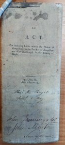
- John Martin’s copy of the Rampisham Inclosure Act.
-

- The Cover of the Commissioners minute book
-

- John Martin’s original survey book.
The Rampisham award was enrolled on the 24th September 1818 at the quarter sessions.

A page from the general survey book.
The total area inclosed at Rampisham was just 800 acres and the book contains many dozens of pages such as this one with hundreds of complex calculations. The section of the survey book shown below shows that he was working in decimals as described on page 30. There was a handy table available [5] which allowed conversion to metric units. Thus four acres two roods and 33 perches converts to 4.706 acres [as in line 2] and 4 acres 1 rood and 23 perches is 4.394 acres [as in line 3].

The problem is that although this works for some of the calculations it is not entirely accurate. In line one for example the nearest the table would get would be 0.969 and in line four, 0.662. The figures in red are the measures of the plots after deduction of the area needed for the new roads.

The page has been cropped at the top. At bottom left is the assumed value of the parish.
The new roads in the parish had to be paid for and a £5 rate was set. For each £5 spent on creating the new roads the landowners had to pay a certain amount based on the value of their rights in the common. Some 50 landowners had to contribute in this way, the list continues well down the page. The value of the parish being calculated at £9773.296.

The copy of the Rampisham Inclosure Award held at Dorset History Centre.

A detail from the final award map.

The completed award map.
Next Sturminster Newton Castle, 1827.
Previous Plush,1810.
Return Inclosure Parish by Parish
2 More values than are shown here.
3 Dilly Robert S Customary Acres: An indeterminate measure. BAHR vol 23 1975
4 The tenants and those owing fealty to the lord of the manor at the Court Baron.
5 Practical Geodesy J Butler William
