The term “map maker” had a very literal meaning in the 19th century. Surveyors not only had to survey the land to be mapped but also had to make the substrate on which the map was to be made. [1] Whilst Martin did not physically make the paper or linen or vellum on which maps would be commonly plotted they had to be prepared in advance of the survey being plotted. We tend to think of ‘ a map’ but the reality was that the end result was almost always preceded by a number of preliminary or working maps. Paper maps were by far and away the commonest with vellum being used only for the final definitive [and legal] version of the map. It is rare to find these intermediate maps although there is one from the time of the Rampisham inclosure in the Martin family archive.
From the 1838 diary onwards we get numerous references, such as this one referring to “pasting paper”.

Pasting Paper for Maps & Went to Batcombe
This activity sometimes extended over several days and occasionally he uses other terms such as,
|
11th April 1845 |
Preparing Paper for Sketch Maps of Abbotsbury Com of Tithes. |
|
11th September 1852 |
preparing Paper for sketch of Ransom |
but “Pasting paper” is mentioned more commonly than preparing the paper in the diaries. There are two possible explanations of its meaning. Today paper comes ready to use, but in the 19th century it had to be treated before use by “sizing” it with an animal product, such as gelatine, or rosin, to avoid ink bleeding into the paper. It is possible that these entries refer to Martin treating the paper himself although an alternative explanation might be that he was pasting the paper on to a canvas or linen backing. Most of the references to pasting are just like the one above but on two occasions we find him pasting a paper map onto canvas suggesting this might be the explanation.
|
7th December 1838 |
and pasting the Stratton Maps on Canvas |
|
22nd September 1852 |
Do Pasting Sketch on Canvas for Ransom |
Pasting paper seems to have been a messy business as evidenced by this entry from August 1838.
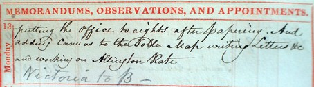
Putting the Office to rights after papering And adding Canvas to the Toller Map writing Letters &c and working on Allington Rate IN PENCIL Victoria to B[ull]
Sometimes, as the entry above shows, it was necessary to add paper or canvas to the map to enlarge it, on this occasion it was canvas but in 1838 it was paper,
|
23rd August 1838 |
Adding Paper to Toller Map and Valued Downfrome land at Chantmarle |
Purchases of paper, canvas and vellum are mentioned in the diaries as are other necessities of the surveyors art some of which are seen here in an entry from 1821:
|
27th April 1821 |
Paid for Ink & Pencil 1s 6d Paid Carriage of Jones’s Plans &c from Lymington 3s 4d Paid for Carriage of Vellum 4s |
In this case he paid 4s for the carriage of Vellum to his house but on occasions he would collect it himself as when he went to Oborne in 1810. There were said to be two parchment manufacturers at Oborne, which is just outside Sherborne and no less than fourteen in Sherborne itself. Why Martin preferred Oborne vellum to that of Sherborne or even Yeovil or Dorchester is not known.
|
5th March 1810 |
Went to Oborne to buy Vellum Paid for Vellum £6 6s 0d |
Vellum, made from calf’s skin was the preferred substrate for maps of record as, if carefully looked after they would last for centuries. [2]
Plotting the Survey.
Eventually the time came for the first lines to be made on the map. Butler Williams is clear that this should be done as soon after the measuring was complete and is quite specific about the time it was to be done. Plotting should only be done in the morning, the afternoon was to be avoided and under no circumstances was any plotting to be done in the evening when “his hand is unsteady from exertion” for “Field measuring is laborious and fatiguing work, and after having spent a long day upon it, the surveyor is in general in no condition for fine drawing or scale measuring.”
“To receive the plotting of the survey, strong drawing-paper is stretched on a board or mounted on linen.” The very first thing to be done was to put the scale marker onto the paper. The paper was subject to alterations in shape with the weather. The next thing to go on were the principal triangles, a pair of compasses and a ruler being used to construct them from their sides.

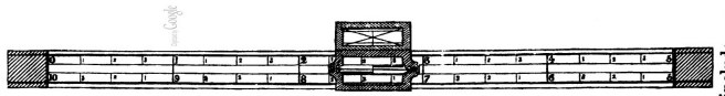
A plotting scale was used to do the actual plotting. On the left hand side is a fixed scale marked out in inches and fractions suitable for the scale to be used. The zero of the scale is opposite the starting point of the line to be plotted but the rule is placed to the left of the line and parallel with it. The main scale has a shorter arm which is moveable up and down and has a 0 point which lies over the line.
The lengths entered in the middle column of the field book are measured off on the line using the main scale and the offsets on the smaller offset scale. “The various boundaries and objects are drawn in Indian Ink…straight lines, rectangular boundaries, such as those of buildings are ruled; irregular boundaries such as streams and winding fences, are drawn freely by the hand…” There is usually a sufficiency of lines and triangles to ensure that the interior detail can be completed. “These points are from distance to distance joined by pencil-lines. Proceeding in this manner from side to side of the triangle, according to the order followed in the field-book, the whole of the survey is laid down in pencil.”
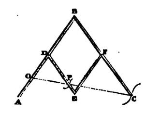
One of Lieut. Dawson’s maps illustrate this process in progress;

There are six primary lines in this map with three principle triangles. There are numerous tie lines which are used to check the accuracy of measurement and numerous offsets.
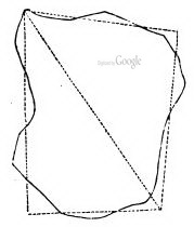
At some time the first line was drawn on the map, seemingly a straight forward decision after all modern maps are always drawn with North orientated upwards. In the past it was not so easy. How this was done will be discussed later. Taking John Martin’s tithe maps as an example there is considerable variability as to the map’s orientation; Maiden Newton is East up, Allington is North up, East Chelborough is roughly North West up, Hook is West up and so on. A part of the explanation for this may be that although paper or canvas could always be added to, as in this example from 1838, maps of record were generally on vellum or parchment which couldn’t.
Casting the Survey.
One of the main purposes of an estate survey was to plot the fields, closes, grasslands and common land. Their boundaries were surveyed in a similar fashion to the principal lines in the parish. As we will see inclosure work demanded a particular type of survey but for almost all purposes it was necessary to calculate the total area of the parish as well as the individual fields etc. Calculating the various areas was known as casting the survey. There are numerous entries in the diaries but none are particularly illuminating;
|
9th November 1810 |
Casting Bishopstone |
|
6th August 1821 |
Measuring Coppice in Melbury Park &c |
|
7th August 1821 |
Casting same & went to Ransom &c |
The total area of the parish was the first to be calculated. Prior to the Tithe Commutation act it appears that “a rapid method generally adopted hitherto” was for the surveyor to inscribe new triangles on the map which equalized the boundaries by eye.
Equalising areas by eye.
These new triangle were constructed on the map. They were not measured on the ground and it is clear that this equalization by eye was necessarily open to individual interpretation. By the time of the Tithe Commutation act Lieut. Dawson did not think it accurate enough. The result was the use of a new scale to which oddly enough Butler Williams does not ascribe a name. Superficially it looked a bit like the plotting scale. You will have to trust me on the maths but if the scale was the equivalent of fifty chains long [in the scale chosen for the map] and if it was then divided into twenty parts and if down the middle of the scale were two parallel thin lines which were [in scale terms] one chain apart then the area encompassed by one part between the two lines represented an area of one rood or a quarter of an acre. As there were twenty parts to the scale the area between the parallel lines represented an area of 20 roods or five acres.
Attached to the scale was a slider equal in length to one part on the primary scale but it in turn was divided up into 40 parts each of which represented an area of one perch. In practice a large piece of transparent paper known as ‘horn’ paper was laid over the map and the areas of all the irregular patches could be measured from the scale.
Using such a scale still required some interpolation; in the crude example shown above the area of the triangle [field] would be one rood, the large square and six perches although if he felt generous the little bits left over might be rounded up to another perch, half perches never being mentioned in surveys.
The instructions by Dawson, which were in effect to make as many triangles as you could, rendered the calculation of area easier since the area of a triangle is half its base × height. The linear distances of the lines were converted [if not already recorded as such] into links. Multiplying two lines thus gave an area that was in square links. The mathematics of turning this into acres, roods and perches is dealt with in the Money and Measures section in the appendix but suffice it to say that this was rarely necessary as by this time tables had been developed which showed the rood and perch equivalents of decimals.
Finishing Off.
Before final ‘publication’ or release the map had a number of finishing touches applied to it. Here there were a number of conventions to be adhered to. The names of rivers, canals and the like ere to be adapted to the contour of the river etc. but elsewhere they were to be written in an east to west direction. “The disposition of the writing requires ingenuity; and it is always to be borne in mind that the utility of a plan depends very much on that facility of reference which is obtained by the relative keeping of the names. The size of the letters must in some degree depend on the situations in which they are placed; but as a general rule, the names should be so written as to be legible at distances proportionate to the importance of the places. Thus, the names of hundreds should be legible at greater distances than those of parishes, villages than single houses, gentlemen’s houses than cottages, &c.”
It appears that Martin used stencils for applying text,
|
12th November 1838 |
Writing to Mr Madeley for stencil Letters &c |
The principal triangles were supposed to be ruled in with very faint red lines, not intended to be erased, to act as a permanent reference to ensure the accuracy of the whole work. Finally when the map was completed it usually had to be painted, sometimes as in 1821 he bought the paint directly and sometimes he made it himself as in 1852. There was an informal colour code, arable land was not surprisingly a straw colour, meadow land a light green and pasture land a dark green – verdigris green in fact. Dwelling-houses were tinted with light flat tints of carmine; out-buildings and unoccupied farm buildings inked in blank. “Streams, rivers, lakes, &c., are tinted with light Prussian blue, laid in flat tints, a second tint being passed along the edges next to the upper boundary of the plan, to make them somewhat darker than the rest; trees are etched in Indian ink with the pen, or washed in with the brush”. Maps were genuinely works of art.

24th September : Making Verdigrise Green & attendg to Farming the remainder of my Wethers for Stafford Fair
|
6th August 1821 |
Pd for Rose Pink &c 2s 6d |
|
23rd August 1832 |
Maiden Newton colouring old inclosures taking up New Roads and entering them in the General Survey |
|
24th September 1852 |
Making Verdigrise Green |
|
25th September 1852 |
Colouring the Ransom Sketch |
|
2nd October 1854 |
At Home colouring Lord Auckland’s Ransom Plan for him |
Copying Maps.
In the course of a survey it is probable that numerous maps would be produced. In the diaries Martin mentions numerous types of map: we find reference to “sketch”, “Skeleton”, “Rough”, and “Fair” maps as well as “Plans” [that then become maps]. All of these appear to be for drafting purposes prior to finalisation on the “fair” map. The commonest references are to sketch maps. According to Butler Williams sketch maps were not drawn to scale and Hollowell but we cannot be sure of this in the case of Martin’s maps. It is reasonable to assume that the distinction represents some variation in quality and the example of a sketch map in “Enclosure Records for Historians” by Hollowell [3] is drawn by hand only and quite basic in appearance. The largest range of terms is used in 1845 at Abbotsbury,
|
17th March 1845 |
Taking off Skeleton Map of Abbotsbury for Tithe Commutation |
|
18th March 1845 |
Working on Abbotsbury Skeleton Map and Went to Abbotsbury in the afternoon. |
|
24th March 1845 |
Working on Abbotsbury Skeleton Tithe Map |
|
26th March 1845 |
Working on the Abbotsbury Sketch of Skeleton Commn Map. [My underlining] |
|
31st March 1845 |
Finished the Abbotsbury Sketch Map and sent the same to London and attending a Timber Sale at the Acorn Mr Mayo’s |
|
11th April 1845 |
Preparing Paper for Sketch Maps of Abbotsbury Com of Tithes |
|
4th October 1845 |
Working on Abbotsbury Enlarged Plan of the Town for Lord Ilchester |
|
19th November 1845 |
Working on the Abbotsbury Town Plan and writing Circular for Chilfrome Rate |
At some stage however the final map had to be produced. The only sequence of entries that details this comes from 1821 when he was preparing an estate map for Lord Eldon at Encombe ;
|
23rd January 1821 |
Preparing Vellum for Lord Eldons Plans |
|
24th January 1821 |
Taking off do [ditto] |
|
27thJanuary 1821 |
Making Ld Eldon’s Fair Maps |
The reference to ‘Taking off’ is explained in the reference to the Stratton map in January 1838;
|
10th January 1838 |
Taking off the Stratton Map Half Size – with Pantograph |
Pantograph
There is one case where he enlarged a map,
|
4th October 1845 |
working on Abbotsbury enlarged plan for Lord Ilchester |
This had to be done by rescaling the map as, “errors are so much increased by enlarging plans with the pentagraph that it ought not to be resorted to where accuracy is required”. Once the definitive map was made it was often the case that copy maps were required. There is only one direct references to him making one.
|
6th March 1838 |
Copying the Town map of Corfe |
Butler Williams tells us how this was done: “It rarely happens that one copy only of a plan is required. When the lines and boundaries are regular, duplicates may be made by laying the plan upon the sheet of paper or vellum on which the copy is to be drawn, and pricking, with a fine needle, through all the angular points necessary to define the figures: the punctures being then connected by pencil lines, the plan is finished by drawing these in Indian ink.”
This was fine for angular maps but not for those with curved boundaries where a copying glass was needed. This consisted of “a large piece of plate glass, set in a frame of wood, which can be inclined to any angle. On this glass the original plan and a fair sheet of paper are laid, and the frame being raised to a suitable angle a strong light is thrown….. on the underside of the glass whereby every line in the original plan is seen distinctly through the fair sheet.”
This can hardly have been an easy thing to do given that there was no electric or even gas lighting to provide the light. Presumably it was illuminated by candle light supplemented by “means of tin reflectors” and the technique must have been limited to small maps [large panes of glass not being available] and could not be used for the transfer to or from opaque material such as vellum or parchment.
Large maps were first traced in Indian ink on transparent tracing paper and then transferred using carbon paper [only it was made from black lead!] to the paper on which the fair map was to be made. There is only one reference to making a tracing in the diaries
|
23rd October 1854 |
Making Tracing of Allington Wilts for Valuation |
but he did buy some tracing paper from Mr Custard the stationer at Yeovil in November 1854.
|
13th November 1854 |
Pd Mr Custard for Two Fair Acct Books -Ransom and 6 Sheets of Tracing paper 10s |
Next Five Acts of the 19th Century
Previous The Perfect Survey
1 The Ordnance Survey of course had their work engraved.
2 Until 1849 all acts of Parliament were ingrossed [hand written] on parchment rolls [inrolled]. These were normally made of goat skin. After that time Acts of Parliament were printed directly on vellum. Since 2015 they have been printed on archival paper. How long they will last for is not known.
3 Published by Butler and Tanner 2000
