Inclosure – the theory.

| Allotments to Henry Luke Dillon Trenchard
no28 |
AND I the said Commissioner by virtue of the Power and authority aforesaid HAVE set out allotted And awarded by these Presents DO set out allot and award UNTO and for Henry Luke Dillon ^Trenchard Esquire ALL THAT Allotment of land situate in the Higher Common containing Two Acres three roods and thirty seven perches and numbered 28 on the said Map bounded on the East by Shroton Drove on the South by the Ridgeway Road on the West by the Fontmell Road and on the North by an Allotment to John Harvey- |
Extract from the Child Okeford Inclosure conducted by John Martin in 1845. Photographed by the Dorset History Centre.
This extract from the Child Okeford inclosure is typical of an award made after the 1801 Inclosure Consolidation Act; it gives the name of the beneficiary, position and number on the map of the allotment, the acreage and finally the boundaries, defined in relation to other allotments or geographical points. It is slightly misleading however as it gives the impression that in the inclosure of a parish or manor it was an area of land that was awarded but this was not the case. What was awarded was an area of land to a particular value and this is a somewhat different thing.
Prior to the 1801 act there was considerable variation in how inclosures were undertaken and unless records from these early inclosures survive it cannot be said that the principles described below apply. Even after 1801 the private act of Parliament that had to be passed permitting inclosure allowed local variation and again it is necessary to examine this to be sure of the principles used.
Unfortunately all too often the only thing that survives from an inclosure is the final award, the actual mechanics of the inclosure process have rarely been preserved. Even the minute books of inclosures that were supposed to be kept by the commissioners have rarely survived. To understand the process of inclosure I refer to “The System of Land Surveying at Present adopted by surveyors and commissioners” a type of vade mecum written by William Stephenson in 1805. In this book he shows novice land surveyors how to conduct the inclosure of an imaginary parish. It is difficult to know just how widely it was consulted -text books for students rarely offer much insight into the real practice of a profession – but at just over 100 pages it is remarkably concise and offers a splendid introduction to the subject. As it was widely available it may be assumed that the principles espoused were also widely accepted and practiced. Many landowners would have found it useful, as did I.
The first thing to do was fix the boundaries of the parish. In theory this was the commissioners responsibility but it was clearly important for the surveyor too as it allowed the area of the parish to be calculated. Compared with a normal estate survey there was a very important and specific requirement; “in the surveying [of] a lordship for the purpose of an inclosure, the quantity of every different quality is indispensably required, in order that every proprietor [1] may be allotted his proper quantity, in consideration for the land he gives up, and his legal claim.” [2] [My emphasis.]
The cropped map below was taken from Stephenson’s book and represents the first stage in the survey of his imaginary manor. The various outline areas do not represent any specific fields or boundaries on the ground rather they are areas of different value or qualities to the land.

There is a lot of detail on the map which does not concern us. Concentrating on the area that I have highlighted, no 56, it can be seen that there has a little letter o in it and it will be seen that all the other areas have one or two letters in; area 47 has a little o and f, area 53 a little d and so on. These represent the rental values of the land in coded form. An area marked a was worth 1 shilling per acre, b two shillings and so on with o being ten shillings and s twenty shillings. Thus area 54 has a value of 15s [g=7 h=8]. [3] The quantities of some of the areas have already been written in but the map remains to be completed. How these values were used is shown below.
There are a number of entries in the diaries where John Martin undertakes this as at Piddlehinton;
| 12th April 1832 | Piddle Hinton Inclosure
Putting Qualities on the Map of West Down – and making alterations in castings on acct of the New Road |
Valuing the land was something of a dark art, the actual value depending on several factors; for example if a particular plot was near the owners home it was worth more than if it was at a distance. The surveyor also had to assess the rental value not on the actual, current, rental value but their assessment of what the value of the land would be after improvement. This part was particularly important, in the rather circuitous language of the time; “Should not land be valued according to what, as far as can be foreseen, it is capable of being, by improvement, but according to what it is in its present state, the principle is unjust”.
The reason was this. Suppose that two proprietors have rights amounting to 20s. If no adjustment is made the first is given one acre that has already been fully improved and is only ever worth 20s. The other however gets two acres worth 10s each but which will in time be worth 20s each. One man’s estate, will eventually be worth twice that of the other even though their allocation was the same. Of course it might be argued that the unimproved land would have to have money invested in it to improve it but of course the improved land had already cost its owner money improving it. We may assume that when the final allotting occurred the man who had already improved his land would not be disadvantaged by being allotted unimproved land and having to start all over again.
Although the map above is of the common, the same technique was applied to all the agricultural land in the parish. Houses and farm buildings were not generally included in the survey but almost nothing else was left out. At a very minimum, the arable fields, common meadow, or ‘ings’ as they were known, any old inclosures in the parish, the common or waste, the old roads and ditches – were all included in the valuation. When all of this was added up the value of our mythical manor was 3704.673 shillings.
The Book of Particulars.
The qualities survey was almost always conducted simultaneously with a particulars survey. This was in essence a conventional map of the lands in the parish accompanied by a ‘Book of Particulars’. The abstract below shows a page from a typical book of particulars. It identifies the field in which the lands’ lie, the area of the field in which the land lay, the owners of the land and the number of ‘gads’ that each owner possessed.
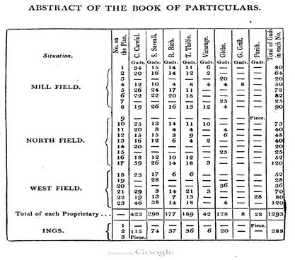
This abstract concerns the open fields. Each field has been broken up into areas of different value represented by numbered zones on the map. The number of gads or individual strips in each zone is recorded against the landowners names.
Note the use of the term ‘Gad’ in the book. There could well be several thousand strips in a manor in the open arable fields and the common pasture or ‘ings’ [meadow]. It would have been very time consuming to have to value and measure each strip or selion in one of the open fields. The term gad is an unusual one and was supposedly a rod of length between 10 and 16 feet wide. Where possible the surveyors [or at least Stephenson] made an approximation to the area [and thus the value] of the strip. From his text it’s clear that Stephenson does not worry too much about the exact measure of each strip; so long as the furlong was of uniform length each strip in the furlong appears to have been treated as of equal width.
In other words the number of gads was simply the number of strips. “The reason it is surveyed and divided as above, for each proprietor’s share, is not altogether for convenience and expedition, but that the principle is equitable”. The problem was that over time the width of each strip would vary unless “they are properly regulated in their breadths, which is seldom the case.” If one year a neighbours land was a little too broad it might not matter too much and would possibly be corrected the next year but, “should an inclosure take place in the mean time, and the lands be surveyed separately, as much as they are deficient in breadth, so much property is lost to the proprietor and his heirs for ever” and worse still it might also affect his claim on the common. This may seem a bit haphazard but in theory all the strips in a furlong should have been the same width unless an owner happened to have two next to each other.
To add up the number of strips in a furlong was the most equitable way therefore but how practical or widely used Stephenson’s method was is not known because, “when the lands are of various lengths, they must be surveyed separately” and this must have been quite frequently the case.
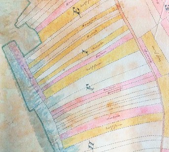
This is a small section of John Martins pre-inclosure map of Chilfrome. The map was a private commission for two of the landowners and was not directly linked to the inclosure. The different colours represent different estates and show how the selions were intermingled.
This section of the pre-inclosure map at Chilfrome demonstrates the problems the surveyor faced. The strips are different in size but so long as the wider ones are regarded as multiples of the narrowest the system used by Stephenson can still be made to work. He would have had to measure the length of strip to get an approximate idea of the areas and he would have had little choice however but to measure the fields in the area of E on the map.
It is not known if Martin used this system for none of the particulars books have survived for open field parishes. This was a massive undertaking. Even within a field there could be any number of areas with different values as well as dozens of proprietors holding anything from one to several hundred gads; and that was just in the arable lands. The same principle was used for the common meadow, referred to by its old name ‘ing’, where the strips of grazing were treated the same as gads but when it came to the old inclosures the waste and the roads and ditches the surveyor had little choice but to measure these. No wonder that inclosures could take many years to complete. The next job to be done was to calculate the value of each man’s estate.
Casting.

Armed with the map and book of qualities together, with the book of particulars the surveyor was now able to calculate or cast the area of the parish and the total value of the parish together with the value of each owners holdings.
The extract above concerns the first line from the book of particulars above. It deals with region 1 of the Mill Field in which there were 80 gads belonging to five owners. The area of the land was measured at 11.426 acres and with a land value of sa, or twenty one shillings, the total value of region 1 was 239.946 shillings. Of this total value C [lets call him Christopher] Careful has land to a value of 34/80 ths of the total which is 101.976 shillings. The surveyor makes this calculation for each of the owners and each of the regions in the various fields. Not suprisingly casting could take up a considerable amount of time. When he was working on the Bishopstone inclosure John Martin started casting on the 9th November and for the next fourteen working days he did nothing else.
At the end of the process the surveyor would have the total value of the manor together with the total value of the owners holdings. The scale of this work is shown below in the next abstract. It is page two of the completed book of casting. This was a small mythical parish with few owners, the size and complexity of casting in a large parish with thousands of strips and dozens of owners must have been a monumental task. At Fordington at the time of tithe commutation there were over two thousand strips and eighty two landowners.

This is page 2 of 2. It records the casting of the open fields in a small imaginary manor with few owners.
Although he now had the total value of the manor and the proportional values for each of the owners the surveyor had to make certain adjustments to them before he could proceed further.
The first adjustment concerned the waste. As the waste was, by definition, uncultivated it had only a nominal value. At Child Okeford, at tithe commutation, the waste was valued at 5s per acre; in comparison the arable land was 25s per acre and the grasslands 45s per acre. When it came to inclosure the land had to be valued at it’s expected value after improvement.
The waste was a part of the Lords demesne land and so, in modern parlance ‘belonged’ to him or her. The problem for the Lord was that he was never able to realise the full value of the waste because of the rights of common held by the commoners. Whilst he had absolute rights over the minerals and timber of the waste, in all other respects his rights were shared with the commoners. It appears from earliest times that the rights of the Lord of the Manor in regard to the waste were circumscribed and not absolute: “The lord has the sole interest in the soil; but the interest of the lord and commoner, in the common, are looked upon in law as mutual.”[4]
The effect of this was that the waste, from the Lord’s perspective, was an asset that unless inclosed could not be easily disposed of, or its full value realised. With inclosure the lords rights over the soil and minerals would disappear and so some form of compensation to him had to be made.
At Rampisham extra land, taken from the waste, was given, in the words of the inclosure act, “as a compensation for and according to their respective rights and interests in the soil of the commons and waste lands.” In this case the amount awarded was left to the discretion of the commissioner so long as it was “fair and reasonable”. Although this too is expressed in an amount of land the actual amount was decided by value; in his mythical manor Stephenson allows a twentieth part of the total value of the manor to be added to the lords valuation.
Similarly it was customary for the rector of the parish to acquire land in lieu of the tithe which would then be extinguished, either completely or in part. The allowance for the rector was usually on generous terms. For the inclosure bill to proceed, it had to pass both houses of parliament and of course the local bishop sat in the House of Lords.
If the tithe was to be extinguished an amount of land, to the value of the tithe, had of course to be added to the rectors share as well as any ‘compensation’ that he and the bishop had negotiated as their share of the booty.
This too was no simple calculation, if we accept Stephenson’s figures to be fairly standard then the tithe was worth “one-fifth in the fields, one-ninth in the old inclosure, one twenty-fourth in the ings [5], and one-twelfth in the common”. Having worked out this portion it had further to be split up into the greater and lesser tithes if there was a vicar as well as a rector; “the tithe of the fields and old inclosure, three-fourths thereof is allowed the glebe, and the remaining one-fourth the vicarage. Ings and common, the whole of the tithe is appropriated to the vicarage.”
Other allowances were also made, the land occupied by the old roads and drains had been included in the overall value of the manor but the value of the new roads and drains had to be removed from it. Roads were a big feature of the inclosures as we will see and approval had to be obtained from the proprietors as to their proposed course. Inevitably the roads and drains would cross lands of different values and each part would need to be staked out and valued individually.

This is a small part of the Rampisham inclosure general survey book concerned with the new roads. On the far left is the number on the map through which the road passes. The total area and value of the section is given and next the amount taken for the new road together with its value in shillings. Note how the value of the land and hence the road varies as it passes from region 1 of the land to region 2. The numbers in red give the revised area and value of the sections.
Likewise there was usually a gravel, sand or chalk pit to be found on the common and some account of its value also had to be made and in many parishes, an allowance for an allotment to the poor was also subtracted for the total. Allottments to the poor were not specified in the 1801 act and so their inclusion smacks of at least some degree of social responsibility on the part of the landowners.
Finally there were ‘old inclosures’; these had to be included in the valuation of the whole manor but were generally not a part of the land to be redistributed.The value of the inclosures was deducted from their owners value.
Allotting.
By the end of what was a long and time consuming process each proprietor now had the value of his land and it remained only to allocate each his due.
The land of a common field manor was divided up into several large fields which were in turn broken up into groups of individual strips, often several thousand in number. Landowners owned various numbers of these strips and they were distributed irregularly throughout the fields. Before inclosure everyone in the manor had to work together; the same crops had to be grown, ploughing, sewing, harvesting and so on all had to be done at the same time.
After inclosure the land of the manor was to be divided up into smaller ‘closes’ surrounded by hedges which were said to be owned and worked in ‘severalty’. In other words each landowner could do did his own thing with his land, independent [in theory] of his neighbours. The surveyors art was to ensure that the land allotted to the landowners kept everyone happy. This was not an easy task. A man’s estate worth £100 might have comprised one hundred one acre strips of value £1. After inclosure he might well have been allotted fifty acres of land worth £2 per acre.
Unfortunately it is not clear how this process was carried out. It may reasonably be assumed that the proprietors had a lot to say about the allotments. Stephenson notes that “Those proprietors having their houses or old inclosure adjoining the fields, &c. ought, for convenience of situation, to have a piece allotted them contiguous thereto, except for considerations that cannot be given up”.
The minute books of inclosure commissioners which might have given us clues were only rarely retained, and the only one surviving in the Martin family archive is for Rampisham and does not help us at all. Very few minute books have ever been transcribed the best known being “The Minute Book of a Leicestershire Enclosure” [6]. Here at a public meeting in 1811 the commissioners “in order that the general Convenience of the proprietors may be attended to as far as possible in laying out the Allotments” requested that the proprietors “make their Requests for situation in Writing”. Subsequent meetings make reference to these requests but no further details are given.
If the question of where the land to be allotted was to lie was one problem, another was how large should the closes be? It is very surprising that little is known about this aspect of inclosure. If. as the argument ran, small isolated strips in the open fields were inefficient and if the only way to improve agriculture was to lay these strips together and inclose them, then what was the optimal size for these inclosures?
Taking the award that John Martin made at Child Okeford it is found that the size of the closes that were awarded varied in size and this cannot just be down to a variation in land quality. At Child Okeford for example George Peach was allotted four closes of 15, 6, 7 and 3 acres in size. As three of these closes were in the same area of common, where differences in value were unlikely, it is difficult to know why they were not all allotted together or at least in more evenly sized amounts.
In his worked example Stephenson refers to first and second allocations of land but fails to explain what this means or how they were calculated. It is tempting to believe that the higher quality land was distributed first amongst the landowners and the lower quality second but that might have proved contentious. With the exception of the common all of this land had previously been under cultivation. A landowner who had spent a lot of time and money improving his land would hardly be pleased if it was subsequently allocated to someone else.
The allocation of the arable and grasslands was one thing but the problem of the waste was another. The landowners of course owned no pre-existing land in the waste yet it had a value which had to be apportioned. The land of the waste was for it’s new owners effectively free land, but the claims on the common were not uniform. The value of rights of common could be extremely variable and were doubtless difficult to resolve. It was perfectly possible that some people had rights of commons but no land whilst, others might have land but no rights of common. How then to apportion the waste?
Stephenson answer was as follows. Firstly the net value of the common was divided into two. A half of the value was to be divided amongst those who had a claim based on the possession of land in the parish and a half to those who had rights of common whether or not they had land.
The net effect of this was to increase the value of everyone’s estates but differentially so as to reflect the varied distribution of rights of common and so on. One problem for the modern historian is that without the original paperwork for the inclosure it is difficult to establish not only what these rights of common were, but what they were worth. Slater’s descriptions of what he calls livings at Stratton seems to offer a way in; “A half-living consisted of four or five nominal acres in each of the common fields, and common rights upon the meadow, common fields and common down, in Stratton, for one horse, two cows, and forty sheep. A whole living consisted of a share about twice as large in the field and meadow, and a common right for two horses, four cows, and eighty sheep.”[7]
At Rampisham the court record prior to inclosure notes;
| “We present the occupier of every whole place in the Parish of Rampisham shall be entitled to 6 leazes for Horse or Bullocks to depasture on the Higher Hill and no more than 6 sheep and two yearling bullocks to be adjudged equal to one Horse or Bullock |
| We present the occupier of every half place shall be entitled to stock the said Higher Hill in the same proportions not otherwise that nine small estates in the same parish shall be entitled to one leaze each for an Horse or Bullock Sheep or yearling in the same proportion not otherwise” |
Here the rights to stock the common are clearly based on the land holding but how much land was a whole or half place. We simply don’t know. At least the notion of whole and half places is logical but what can one make of the rights of common recorded at Child Okeford in a survey from 1826? All were copy holders or lease holders for lives but how on earth would they be valued?
| Number of commoners with right | Horses | Beasts | Sheep |
| 4 | 1 | 2 | 10 |
| 1 | 0 | 2 + 2 more every third year | 5 |
| 1 | 0 | 2 + 3 the two following years | 10 |
| 1 | 2 | 2 | 15 |
| 1 | 1 | 1 | 7 ½ [sic] 2 years in three. |
| 1 | 0 | 3 | 10 |
Stephenson had no difficulty in assessing the rights of common in his imaginary manor. His 6 proprietors had 12 rights between them so each right was worth 1/12th the value of the remaining half of the common. Thomas Thistle had two such rights so the remaining 1000 shillings would have got him 1000÷12×2 =167 shillings. Worth considerably more to him than the value gained by his land holdings.
The end result of this process, which could well have taken several years to complete, was a list of landowners together with the value of the land that they owned in the parish. The Commissioner had agreed with them the position of the new roads and the surveyor had doubtless also received a number of requests from the landowners as to where they wanted their allotments to lie.
The laying out of allotments started with the map. During the course of the survey reference points had been placed within the parish and using these, by a process of trial and error, an area equating to a particular value could be marked out. As even modest sized closes might cross land of different values there were no certain rules that could be applied but “when the value is given, a line must be drawn upon the plan…such a distance as is supposed will be far enough…”. As the qualities were known from the map a calculation would be made as to what the value of the land was that lay between the two lines “and as their sum is too much or too little, so must the line be altered, until it cuts off the proposed value.”
As if this were not complicated enough there were occasions when the allotment ran up against the line of a new road at which point the value of the overlapping part would be deducted from this allotment and added to another one of that proprietor’s. On other occasions a particular allotment might come up to a natural boundary but not quite meet it. In this case that allotment would be extended to the boundary and the extra amount would be deducted from another of that proprietors allotments elsewhere. It all sounds a bit hit and miss and I wonder how many of the landowners involve really understood what was going on?
Once the position of the allotments had been agreed with the landowners the final stage was to transfer the allotments to the field by staking them out; “After the allotments are thus measured with the scale upon the plan, and the dimensions entered into a field book, the same rules must be observed in setting them out in the field with the chain, and their situation will be in the same position as upon the plan. For the convenience of setting out the allotments, it is proper first to set out the roads and drains.”
This was an important moment. At Newbold in Derbyshire once the stakes had gone into the ground the commissioners “declared that it shall be lawful for the several Proprietors to enter upon their respective Allotments so soon as the same shall be staked out, & to ditch fence & enclose the same” and we can assume it was no different elsewhere.
From the Commissioner and Surveyors point of view the job was almost done. They had to produce the final award with it’s annexed map which transferred everything to a parchment document which would be ‘signed, sealed and delivered’ to the rector or churchwardens of the parish. Meanwhile a copy of the award was taken to the local quarter sessions where the clerk of the peace officially accepted it into the records of the county. In the 18th century the content of the award was engrossed into the quarter session records; quite literally written out by hand in the quarter session record book. In the 19th century the copy was sent to the quarter sessions who ‘inrolled’ it in the record book and arranged for storage in what we know today as the county archive. This from July 1818,
Abbotsbury Inclosure Award
“The Award of Richard Webb and William Jennings the Commissioners appointed in and by a certain Act of Parliament made and passed in the Forty ninth year of the Reign of his present Majesty inituled [sic] An Act for inclosing Lands in the Parish of Abbotsbury in the County of Dorset bearing date the sixteen [sic] day of April one thousand eight hundred and fourteen was brought to the Clerk of the Peace of the said County the Twenty fourth day of September one thousand eight hundred and eighteen was required to be inrolled pursuant to the Directions of the Act”.
Previous Who’s Who in inclosure
1 In this context a proprietor could be a freeholder of land, the lord of the manor and his demesne land or a copy or lease holder for lives. Any of these people were technically landowners.
2 Stephenson W The System of Land Surveying at Present Adopted by Surveyors and Commissioners in Old and New Inclosures, 1805
3 I have no idea why he did not use oe which would also have given a value of 15s.
4 Blackstone ibid
5 Johnson S A Dictionary of the English Language 1756 “In the names of places signifies a meadow”
6 The Minute Book of a Leicestershire Enclosure by M. W. Beresford, M.A. The inclosure was at Newbold Verdon and Newbold Heath.
7 Slater, Gilbert The English peasantry and the enclosure of common fields 1907
