If anybody knows anything about tithes it is the maps that were produced as a result of the Tithe Commutation Act 1836. For those who have jumped to this page first some introduction to them may be helpful. The act required the production of a map to accompany what was known as the apportionment. It was a truly impressive effort for twelve thousand seven hundred and thirty three tithe districts [which were for most practical purposes parishes] were eventually commuted and all had a map annexed to them. In what follows the words ‘original map’ are used to indicate the map submitted to the Tithe Commission for endorsement whilst ‘copy map’ is used to indicate those maps made from the original after the endorsement of the map.
Tithe maps fell into two categories.
First Class Maps
The advisor to the Tithe Commission Lieut. Robert Kearsley Dawson stipulated that these maps be the result of an entirely new survey of the parish, undertaken to specific standards so that the map could be tested in the office of the tithe commission. Surveys involved dividing the parish up into a series of triangles and constructing a map based on these triangles. To test a map meant that it had to be drawn to a large enough scale such that the accuracy of these triangles could be tested by measurement on the map itself. For example a right angled triangle with two sides of length three and four must have as it’s third side a length of five BUT unless the map were drawn at a large enough scale none of the sides could be measured accurately enough to confirm their lengths. Dawson stipulated the scale of 3 chains [66 yards ] of real land to one inch of map as being the minimum scale that could be used. This corresponds to a scale of 1 mile of real land being represented by just over 26 inches [66 cm] on the map. For larger parishes , many miles in extent, this would have resulted in maps which were physically very large indeed. Such surveys were expensive to conduct and relatively few were made. In Dorset only three first class maps were made and none were by John Martin. First class maps had one major virtue however which was that because they could be tested their accuracy could be certified – potentially useful in case of legal challenges.
Second Class Maps
Opposition from landowners scuppered Dawson’s plans. They simply would not pay for a survey they did not feel was necessary. As a consequence a revision to the act enabled any map of the parish to be used so long as the landowners agreed to it’s accuracy. These maps would not be tested and could not be confirmed as accurate. These second class maps could be drawn to almost any scale although generally they are drawn to a scale of 6 chains [132 yards] of real land to one inch of map. Second class maps did not require a new survey and could be constructed from pre-existing estate or other surveys of the parish and it is likely that this is the commonest basis for second class maps . There are two cases where Martin records collecting, or at least attempting to collect, old maps from landowners,
| 22nd August 1838 | Charminster Commutation Attending at Charminster to receive Maps of Landowners When Mr James Henning & Mr Sherrin did not produce theirs |
| 13th November | Sydling St Nicholas commutation Attending at Sydling to receive Maps 2-2-0 |
Lieut. Dawson had stipulated that if old maps were used in this way then, “If the plan be of old date…or if plans of portions only of the parish be found,” the surveyor was required “to test and combine them into a plan of the entire parish, adding such further detail as may be required.” This must have posed considerable logistical problems. To have a pre-existing map of the whole parish may have been a rare event, it was much more likely that most of the large landowners would have maps of there own lands but less so that the small owners did. In this case there may have been large areas of the parish belonging to the smaller landowners which had hitherto been unmapped and the surveyor had somehow to incorporate in the new map ; it may have been easier in some cases just to start afresh.
In any event where old maps were used they appear to have always been redrawn by the surveyor . Very occasionally the pre-history of a tithe map can be found. The production of a new map from an old one is seen at Child Okeford is one of those occasions. Child Okeford had two manors, with the largest belonging to the Trenchard family. In 1826 William Trenchard ordered a survey of his manor known as Child Okeford Superior. The only part of the survey to survive is the book of particulars and naturally enough this does not include the tenures of the other manor in the parish, belonging to the Seymer family . A page from the book is shown below;

This crop shows the entry for Edward Rose. The top line of the entry gives his name and tells us that he inherited the copyhold tenancy from the widow of Robert Rose, almost certainly his mother. On the left are a series of numbers , 73 ,76 ,249 and so on. These are plot numbers which refer to a map but these numbers are not sequential and across the whole of the survey there are numbers missing. The only explanation is that the map to which the plot numbers relate was a survey of the whole parish and the missing numbers refer to the land of other owners. This map is now lost but a few years ago a document was passed to the holder of the village archives in Child Okeford by another villager. It was a black and white copy of a map. The villager had found it in the papers of another villager who had died and left them to her. The original map is lost and the quality of the copy is poor.

At the bottom of the map we are told that the original survey was conducted by Wm Jennings, although the date of the survey cannot be made out. This map was copied from the original by another villager, T[homas] Holdway, for a local farmer, William Wiltshire, in 1834. It is tempting to imagine that the original of this map was the one that accompanied the 1826 survey but we don’t have any evidence for this.

The point is that the field names and plot numbers referred to in the 1826 survey, and on the 1834 map, and on the tithe map are identical. Martin clearly used this map, or the original from which it was derived, to draw the tithe map in 1840. Despite a gap of 16 years little had changed in the land in that time.
Second class maps were never intended to be used as the basis for land registration or legal disputes over boundaries and as they could not be tested by the commissioners they could not be certified accurate. They were nevertheless remarkably durable and were used in land sales. The Trenchard family eventually sold their manor of Child Okeford Superior to the Portman family and in the late 1880’s it was owned by Claud Berkley Portman. In 1906 for personal reasons he sold the manor to his own father, William Henry Berkley Portman for the sum of £45,000. The Bill of sale specifies the land sold and the field names and plot numbers refer to the tithe map constructed 66 years previously.
The Anatomy of a Tithe Map.
At some stage the land surveyor had finished his work, he had gained the approval of the draft apportionment and map by the landowners, tithe owners and the assistant tithe commissioners and they were sent to London for final approval by the Tithe Commission.
For the purposes of the Tithe Commutation Act three versions of the instrument of apportionment and the map were required – the original and two copies, the copies being made after the original map had been approved. One copy was to be lodged with the Registrar of the diocese in which the parish was situated whilst, “the other copy shall be deposited with the incumbent and church or chapel wardens of the parish for the time being, or such other fit persons as the commissioners shall approve, to be kept by them and their successors in office with the public books, writings, and papers of the parish.”
Once the award had been confirmed however the landowners were free to make engraved copies which were then free to be sold, as we will see later.
The original maps are of course now out of copyright but two of the genealogy companies have created images of them which are within copyright. The Genealogist provide scans of the original maps which are now held at the National Archives. Originally these scans were in grayscale but some have now been reproduced in colour. Ancestry provide coloured scans of one of the copy maps for Dorset parishes.
To avoid copyright issues, I have used the map below taken from Wikipedia. The original source of the picture being http://www.llgc.org.uk/en/ , and it is taken that this map is free of copyright issues. The map shows all of the essential features of a tithe map albeit not in Dorset but St Woollos in Wales.
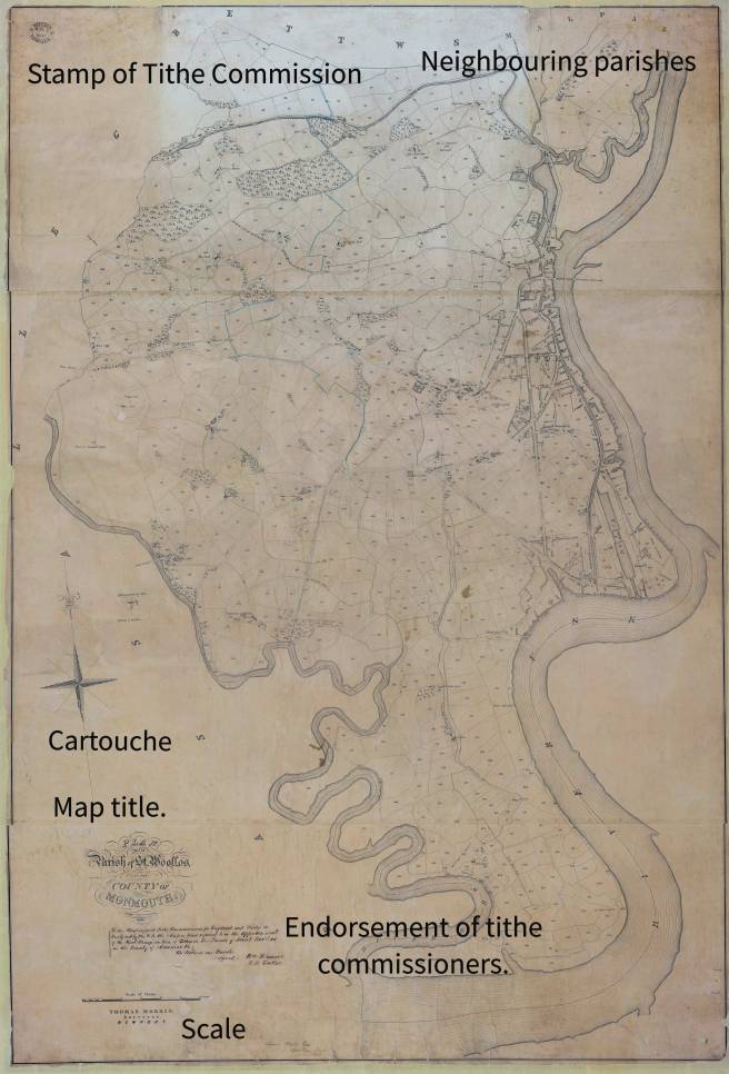
The Stamp of the Tithe Commission.

On receipt of the map in the Tithe Commission it was officially stamped , usually in the left or right upper corner. There is here a puzzle as many of the original maps bear multiple stamps suggesting that they were received in the Commission , returned to the surveyor , sent back to the commission and so on. On the other hand copy maps only ever bear one stamp which is always the same date as the last stamp on the original. These were made only after the original map had been approved. This is seen on Martin’s map for Dorchester Holy Trinity.
| Parish | Date Stamps on Original Map | Date Stamps on Copy Map |
| Dorchester Holy Trinity | 9th June 1841
30th June 1841 18th December 1841 | 18th December 1841 |
The puzzle is why these maps were returned in the first place. In theory second class maps were not to be tested so long as the landowners were happy with their accuracy so what caused them to be returned? A puzzle that will never be answered.
The Cartouche
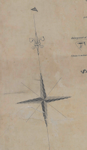
Cartouches vary in their complexity an ornateness from map to map. Despite this sometimes the features on one map are very similar to those on another and there is the suspicion that they were stencilled on rather than drawn. Certainly Martin used stencils as in 1838 he noted he was “Writing to Mr Madeley for stencil letters etc.” I have not checked other maps but John Martin’s always point to true north or more likely to the pole star which is very close to it.
Map Title

Sometimes they were maps and sometimes they were plans but almost all are of the ‘Parish of’ somewhere or other. Strictly speaking what they were was maps of ‘tithe districts’ which were not always the same as the religious parish. For usually unexplained reasons many parishes had odd bits of titheable land that were in another parish. These extra-parochial portions of land were usually drawn in on a blank part of the canvas. On the map of the parish in which these outlying parcels of land were found there is usually a comment to the effect that that field or mill belonged to the other parish.
As with the cartouche the title is highly ornate and in this example the map was probably engraved as above the 1845 it reads “Standige and Co, Litho , 77 Cornhill, London.”
Neighbouring parishes.
Around the edge of the map will be found the names of the neighbouring parishes. Boundaries had to be agreed with these parishes and if there was any question of dispute then the matter had to be referred to the Tithe Commission to resolve. Later in the century civil parishes would be introduced but in the 1840’s the parish was still a religious parish being “that circuit of ground which is committed to the charge of one parson, or vicar, or other minister having care of souls therein” [Blackstone Commentaries on the Laws of England 1765]. The Tithe Commutation act and various amendments to it gave the secular commissioners extensive powers to determine what had hitherto been a religious jurisdiction.
Landowners and tithe owners endorsement.
These are usually found on the earlier maps and were presumably intended to impress the Tithe Commissioners with the accuracy of the map and the support of the landowners and the tithe owners in recommending the use of the map. The are not usually found on the later maps and it is not known how widespread this practice was , if it was necessary or even worked. Martin provides an example of this practice at Stratton. The original map has been heavily cropped so we cannot see how many stamps it had on it and if this strategy had avoided the to’ing an fro’ ing seen on some of the other maps.
At Stratton seventeen landowners signed the map or made their mark with the three tithe owners [the biggest of whom was Winchester College] having their attornies sign for them.
| 19th February 1838 | Stratton Commutation Attending at Stratton when the Map was signed by the Proprietors |
| 7th May 1838 | Stratton Commutation Journey to Stratton getting more signatures to the Map and Valuing the Wracklefords for dividing the Rent Charges between the Farms |
| 8th May 1838 | Stratton Commutation Journey to Stratton taking up the Lots in Broad Mead and getting more Signatures to the Map and waited on Mr C Henning at Dorchester respg copy of agreement |
The endorsement of the Assistant Tithe Commissioners
Scale

Once the land surveyor had finished his work he produced a draft of the apportionment and the map. An Assistant Tithe Commissioner then attended the parish to report on the draft award and map and confirmed the landowners and tithe owners were satisfied with the way the award had been conducted. The ATC then wrote formally to the Tithe Commission in London and endorsed the map usually in the lower right corner. , The award and map were then sent to London.
In this case the scale is closed to these endorsements and in the example above it would appear that the software used to blend separate images together did not work quite correctly. Generally although the scale is included on the map there is no indication as to whether it was 3 or 6 chains to the inch. As a small part of this map indicates it had been enlarged to 3 chains per inch the presumption must be that the rest of the map is to a smaller scale.
The endorsement of the Tithe Commissioners

Once the tithe commissioners were satisfied with the map they attached their endorsement. In this case the form of the endorsement tells us that it is a copy of a second class map.
First class maps were endorsed in the following way :
“We the undersigned Tithe Commissioners for England and Wales do hereby certify the accuracy of this map and that it is a map or plan referred to in the Apportionment of the Rent Charge in lieu of Tithes in the Parish of x in the County of y.
In testimony whereof we have hereunto subscribed our respective names and caused our official Seal to be affixed this xth day of whatever month in the year of our Lord one thousand eight hundred and something or other.”
The seal was not a wax seal but an embossed seal formed by a metal die being pressed into the parchment.
Second class maps were endorsed differently :
“We the undersigned Tithe Commissioners for England and Wales do hereby certify that this is the map or plan referred to in the apportionment of the Rent Charge in lieu of Tithes in the Parish of x in the county of y as witness our hands”.
Copy Maps
The endorsement on second class maps makes no reference to the accuracy of the map. In general copy maps are endorsed as follows :
“We the undersigned Tithe Commissioners for England and Wales do hereby certify that this is a copy of the map or plan referred to in the apportionment of the Rent Charge in lieu of Tithes in the Parish of x in the county of y as witness our hands”.
Note the addition of the word ‘copy’. However if exceptions really do prove the rule the historian will find plenty of examples where the word ‘copy’ has been omitted from what are truly copy maps.
But what of the first class maps ? Only the original map was considered to be accurate and copies of the original were not subject to testing in the way the original was. The Commissioners could not then verify the accuracy of the copies and so they were endorsed in the same way as a second class map with or without the addition of the word copy to it.
Signatures.
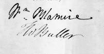 |  |
The original map , be it a first or second class map, was always endorsed with the signatures of the Tithe Commissioners in their own hand. Copy maps were just that and did not have to be signed by them BUT if the copy map was a true copy of the original then whatever appeared on the original map had to be reproduced on the copy, including any signatures. It can be seen that the ‘signatures’ on the copy map are in the same hand, they are not genuine signatures but facsimiles of the original.
John Martin appears to have signed both the original and copy maps himself – unless that he had an excellent forger in his employ.
Supplementary signatures

On some maps, usually at bottom right or left, are the initials of some other person, with or without a date. These are not the initials of an Assistant Tithe Commissioner, but someone who has worked on the map, most often an assistant. In this example two of Martin’s assistants, John Pyne and one other whose initials shown here don’t quite fit James Fitzgerald who we know was working with Martin in 1841.
Internal Detail
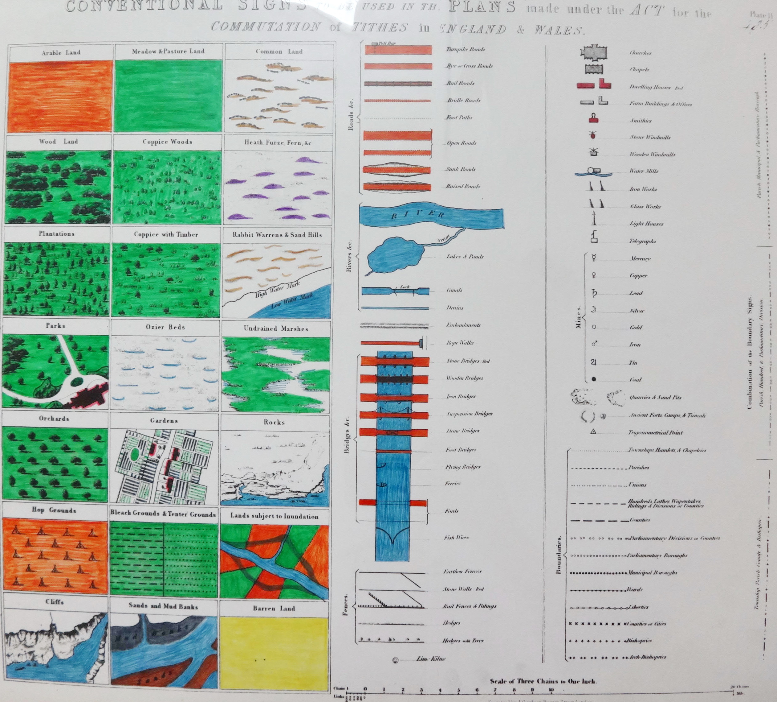
Dawson provided a list of signs that he wanted used on the maps. I have not been able to find the original but someone else has [my apologies to whoever it was but I have forgotten where I found it] and also gone to the trouble of colouring it in.