Reading the Landscape
Several books have been written about the appearance of the English Countryside, the most famous of which is W G Hoskins ‘Making of the English Countryside’. Other favourites are the History of the English Countryside by Oliver Rackham and Richard Muir’s 1981 ‘Shell Guide to Reading the Landscape’ from which the above title is taken. Closer to home is Christopher Taylor’s ‘Making of the English Landscape – Dorset’ from 2004 which provides a more up to date view on thinking.
Celtic fields and Strip Lynchets
Celtic fields and Strip Lynchets
Perhaps the oldest fields that may be found are so called ‘Celtic fields’ which are found throughout Wiltshire and Dorset. This rather vague term is usually applied to those field structures that were laid down before the Saxon conquest. Typically they were square in shape having sides about 150’ or so long. They tend to survive only where later cultivation has not destroyed them and the best source for finding them is the list included in those volumes that comprise “An Inventory of the Historical Monuments in Dorset”. These may be found on line at www.british-history.ac.uk/search/series/rchme They are rarely visible from the ground and even on aerial photographs they can be hard to spot.
Commonly associated with Celtic fields are what are known as lynchets or strip lynchets. These are plentiful, particularly around Worth Matravers, but may be seen pretty well anywhere in the county where there are hills. Once seen they are unmistakable. They are not confined to the south west of England though , being found throughout the country.
There are two characteristic features of strip lynchets – the presence of a scarp and a terrace. Lynchets such as the one shown below cannot be accurately dated unless they have been excavated. They were widely used over the millennia with some dating from neolithic times whilst others may have been created in Roman times. Taylor in his study of the Dorset countryside attributes most to the medieval period.

These lynchets are in Bradford Peverell. Note the flat terrace and the steep scarp. It is believed that lynchets like these were formed by ploughing around the side of the hill rather than up and down it but it is not inconceivable that they were excavated. Over the centuries a combination of ploughing, together with soil erosion caused by the forces of nature, tended to move soil from the inner part of the terrace outwards. In the picture above the scarps themselves appear to have acquired ridges and this is due to rain washing down detritus which then gets caught in long grass. This in turn catches more detritus and so on. This appearance is common on any steep hillside where the effect is produced by the forces of nature only.

At Compton Valance there are extensive ‘Celtic’ field systems with numerous lynchets some of which can be seen in the background in the above picture. To complicate matters there appear to be a collection of selions [see below] in the fields being grazed by the sheep. This picture also taken at Compton Valance also shows selions in the foreground as well as two strip lynchets behind them.

Why were these lynchets formed ? As Taylor commented “It was surely no easy task to plough such terraces or even to reach them.” The general consensus is that they were formed in times of ‘land hunger’ when cultivatable land was either exhausted or at at premium and this was the only land available.
Ridge and Furrow
Less commonly seen than strip lynchets are what are known as ridges and furrows. These have a characteristic appearance as can be seen below. Within the field are numerous, convex strips having a central ‘ridge’ and separated from it’s neighbour on each side by a furrow. Archetypically these strips are said to be 220 yards long by 22 yards wide enclosing an area of one statute acre, the result of one day’s ploughing by a medieval plough team. Like most archetypes this is a nonsense and the length and width of the strips varied enormously. Known in some areas as strips, in others as ‘selions’ and in still others as ‘lands’, they are usually taken to be evidence of an open field system [see here] but this is not always the case [see below].
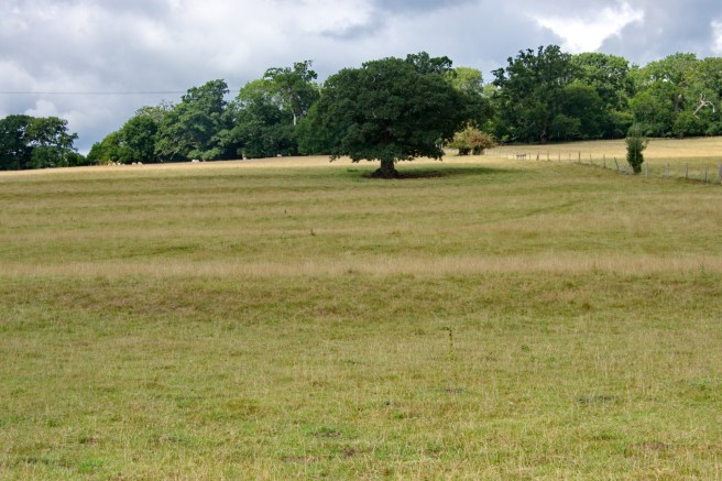
In many, if not most, areas, they have disappeared, having been ploughed out by modern agricultural methods; where they have survived it is often because, as in the field below, land usage was changed from arable to pasture.
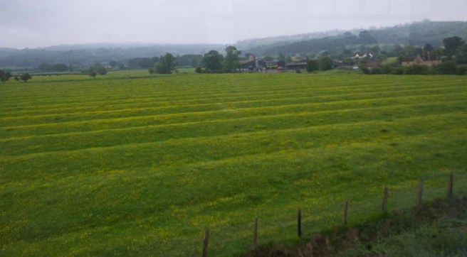
Individual strips were called selions or lands. This fine collection of selions was spotted from a train on the Gloucester and Warwick Railway. Unfortunately the weather was not the best and I cannot remember precisely where on the line we were.
Finding remains of selions in Dorset is not easy. Land that was inclosed and given over to cattle or sheep has often [subsequently] been returned to arable cultivation and modern ploughing techniques has destroyed the evidence. This set is to be found near Winterbourne Clenston and was taken from the road. Unusually the strips run transversely across the slope of the hill.
Such remnants as these, although faint, should serve to remind us of the long march of time. Taylor in his book notes that Winterbourne Clenston, now little more than a name on a map, was one of the 70 or so Dorset villages that were abandoned in the 14th century. In 1315 it was a small, but active, village operating a three field, open field, system of which the above are the remnants. Two hundred years later the village was abandoned.
Those unfortunate enough to be stuck in the traffic on the A35, Dorchester By-Pass, can see, in the evening light, the ridges of the extensive open field system that once enveloped the town of Dorchester. In a few years they will doubtless be gone as the relentless replacement of farm land by housing takes it’s toll.
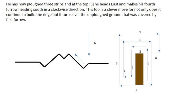
To produce the classic ridge and furrow appearance the ploughman had to proceed in a particular way, using a plough whose mould board turned the ground over to the right. The following images show how this was achieved.


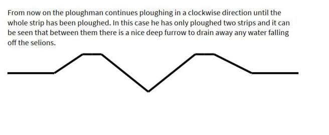
The convex shape was designed to throw water off the strip which then drained away in the furrows. The strips were grouped together in what were called furlongs and these were orientated in such a way as to take advantage of the topology of the land and so further assist the drainage.
There were many open fields where drainage was not required and here a different technique of ploughing was used leaving a relatively flat ridge, although each strip was still separated from its neighbour by a furrow. When this effect was required the next years ridge was formed by starting ploughing , not in the middle of the strip but at it’s edge – that is in last years furrow. These flat strips are shown below; note the very slight S shaped curve to each strip. Ploughs pulled by oxen took a good deal of space to turn and it was necessary to begin their turn before the end of the furrow.

Relationship to the Open or Common field system.
Ridge and furrow are usually taken to be evidence of an open or common field system but this is not necessarily the case. During the 15th and 16th century large swathes of hitherto uncultivated downland were brought into agricultural use. Mostly this was given over to grazing for sheep but some was brought under the plough. These downland arable fields were not farmed in common but in what was known as severalty – that is by individual farmers. They were however often ploughed in the same way as the open fields but were generally much narrower being perhaps a quarter of the width of a normal strip and were called ‘narrow rig’.
Considering the condition of modern arable fields on the downland, where chalk and flint seems to outweigh soil by a huge margin, ploughing such land with horse or oxen must have been very difficult and doubtless the narrowness of the strips reflected that difficulty. The ridges also tend to be lower a fact that Taylor attributes to the temporary nature of this kind of cultivation, and the thinness of the soil.
The need for land drainage in an era before clay drainage pipes were available, meant that the system of ploughing described above survived into the 18th century . In the diary of James Warne from 1756 we find him choosing to create ridges and furrows. Warne farmed at Woodstreet Farm and Puddletown and he records ploughing in a fashion to create ridges in some of his [inclosed] closes at Puddletown.
6th February 1756 I must go to Piddle to set out ridges in lower hog leazes
7th February 1756 Struck [set] out 17 more ridges at Piddle.
Eventually he set out 36 ridges in his closes over the next 8 days. With the introduction of clay drainage pipes the necessity for ridges and furrow declined. Today they are only found where arable lands gave way to pasture and modern ploughing practice has not destroyed them.
Categories: In Depth
