|
Parish 25 |
Date of Agreement / Award |
Date of Confirmation of Apportionment |
Cheselbourne |
20/7/1839 |
04/07/1842 |
|
Date on Map |
Scale of Map |
Signed |
|
1840 |
7 chains |
John Martin |
The commutation at Cheselbourne was another award made by Aneurin Owen and for the usual reason that the seven year average did not represent the true rent charge. The Rector is not named but was Thomas Wickham Birch who had been in the Parish since 1820.
This was a large parish with some two and a half thousand acres under cultivation and it is worth just spending a while on the statistics of the parish. There were two large landowner – the Lord Rivers who owned almost half the land and the Revd. Edward Wills who owned three hundred and fifty five acres and a further twenty four land owners who owned a rough average of twenty five acres or so each.
Lord Rivers had fourteen tenants the largest of who farmed over seven hundred acres and the smallest just over five. Wills had one tenant and the other land owners either farmed the land directly or had tenants or who farmed directly and had tenants – in short an enormously diverse mixture of tenures and farm size.
Large parts of the parish, like Stratton, were still being farmed under the common field system. A century earlier and every parish would have had the equivalent of Cheselbourne’s North, Little, East, Middle, Water side, Long lands and Range open fields. On the ground there was nothing to demarcate them but on the map Martin distinguishes them by the use of red lines. Running through the centre of the map with the village clustered long it was one of the innumerable tributaries that eventually led into the River Piddle. In the East and South of the parish were extensive open arable fields whilst to the west the principal farm, occupied by Caines, as Lord Rivers tenant was enclosed. There are nine hundred and forty plots; numbers seventy six to seven hundred and seventy five were all strips in the open fields. These six hundred and ninety nine strips were typically about a half to three quarters of an acre in size and separated from each other on the map by a – – – – line indicating they were not bounded by a hedge or fence. Individual strips were not apportioned any part of the rent-charge which was instead attached to the total of a man’s holdings. This must have created complications when the parish was finally inclosed but there is no evidence of reapportionment.
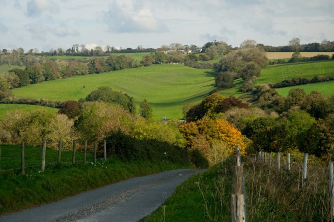
Looking towards Bramblecombe Common, Cheselbourne. In 1840 the road ran out at this point. It served only as access to the common and to the open field- Little Field- as it was called, that flanked the road on either side. Nothing today gives any clue of this ; the only evidence for an open field system being John Martin’s map.

Today the road shown above leads down into the valley below Bramblecombe down. It then turns sharp right and heads to Dewlish. In Martin’s day only a green lane existed here and this road is clearly an inclosure road. To the right is East Down over the brow of which was another large open field known, unsuprisingly as East Field.
Many parishes in Dorset had remnants of the open field system. At Child Okeford the tithe map shows odd isolated strips, known as quilletts, marked out by a hatched line in otherwise enclosed fields, and frequently, as at Cheselbourne, there are groups of narrow rectangular enclosed fields of perhaps two or three acres in size. One can only speculate as to the circumstances of their formation but are probably the result of a past landowner acquiring a few strips and then consolidating and inclosing them.
With such a large number of individual strips to be mapped it might be thought that commutation in a parish where the open field system prevailed might be onerous but this might not have been the case. Open parishes frequently retained strong manorial courts which maintained [although not at Stratton] details of the tenants holdings and often held maps from previous surveys. Of the six hundred and ninety nine strips at Cheselbourne almost a half were owned by freeholders who were not subject to the courts rule. But open field farming demanded close cooperation and at Laxton in Nottinghamshire [for example] there was a separate Jury which regulated the course of agriculture which all had to obey.
Since the essence of commutation was after all not the map, but the division of a fixed amount of money over a fixed amount of land the usually excellent records of a parish operating the open field system may have made the task somewhat easier. Even so it would appear that the commutation went on for many years as the only record we have is from the 1845 diary and the map itself was not received in the TC until 1842.
Large parts of Cheselbourne had been inclosed prior to it’s final inclosure in 1844 ; the Ordnance survey 6 inch to the mile map [1888 -1913] shows that the one hundred and twenty one strips in the North Field had been reduced to four closes and one hundred and fifty nine strips in the East field had been reduced to eleven closes. Aerial photography reveals that after taking account of new farm buildings and roads this is more or less the same as the situation today. There are two entries from the diaries concerning Cheselbourne.
|
7th August 1845 |
Answering Various letters -and looking into the Cheselbourne Com Rate respg the Rectors Rate – Mr Wm Jennings Mrs B Jesty and Miss M dined with me on Venison. |
|
6th September 1845 |
Reced of Messrs Alford & Chandler Revd Birch’s Cheselbourne Rate £2 5s 0d |
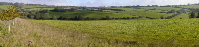
Looking from Streetway Lane over the old ‘Little’ field towards Dewlish. No trace of the open fields can be seen today.
