|
Parish 20 |
Date of Agreement / Award |
Date of Confirmation of Apportionment |
Compton Vallence |
6/3/1839 |
8/3/1841 |
|
Date on Map |
Scale of Map |
Signed |
|
1840 |
8 chains |
John Martin |
When Hutchins published his first edition in 1774 he noted that Compton Valance “was once a pretty large village of late much depopulated”. The reason for this is not clear. There is an inclosure act inrolled in the Easter Quarter Sessions for 1810 for an inclosure undertaken by Francis Webb. It is likely though that this was an inclosure of the common pasture rather than any open fields, although there is good evidence for their existence as can be seen below : to the north of the parish are a number of strip lynchets but in the south there is one field containing ridges that are too narrow and irregularly arranged to be anything other than selions. Inclosure of the common fields may have occurred earlier in the 15th or 16th century and would certainly have accounted for Hutchins comments.

Towards the left hand edge can be seen the remains of a number of selions.

The remnants of selions. Note their narrowness and their irregular disposition in the field.
Deriving it’s name from it’s situation in a valley and the Valence family, who acquired the land in 1247, at some time it acquired an extra L which is how it is named on the tithe apportionment. Despite it’s proximity to Dorchester this must have been an isolated parish. There was one landowner, Robert Williams, who was from Littlebredy his land being worked in almost it’s entirety by Richard Davis.
There are no diary entries for the commutation but at one thousand two hundred and forty six acres this was a profitable parish for it yielded £257 19s 0d in tithe rent-charge. There were no moduses. It’s one land owner, Robert Williams, the rector, William Perceval Ward, and 119 inhabitants occupied just 9 houses. There were 11 families in the village [1] almost all of whom, 102, were agricultural labourers. If this seems to be an excessive number it is worth noting that the enumerator did include children in this classification. It is also worth noting that at some stage the census was edited and some of the children had their designations as agricultural labourers struck through. Any child over the age of 5 retained the designation. Seemingly only children under 5 were exempt from working on the land.
The church is pictorial, even to the extent of having the path to the church door visible and what appears to be a cloud or murmuration of birds over the nave end. It is an accurate depiction for not the least reason that it was rebuilt whilst Martin was there undertaking the commutation.
The maps are drawn to one of the smaller scales and the original and copy maps are not greatly different both are signed by Martin and there are supplementary signatures which relate to the date it was received in the Tithe Commission. On the original map J Pine, Martin’s assistant, wrote his name in the bottom right hand corner but on the copy he has just initialled it JP.
There are no diary entries for the commutation. Of all the Dorset parishes which Martin mapped this one has changed the least. The pattern of housing has changed slightly, the roads are all in the same position and even the withy beds and coppices remain where they were.
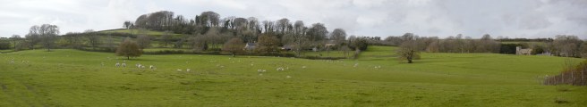
Today the village is famous for it’s snowdrops in the spring, which given that most of Dorset is covered with them, says something about the display. From the bottom of the valley there is a most attractive vista.
1 With a scattering of others there were the Gale’s, Driscott’s, Meeches, Palmer’s, Mitchell’s, Churchill’s, Short’s, Watt’s, Barber’s, Galpin’s and Symond’s.
