|
Parish 37 |
Date of Agreement / Award |
Date of Confirmation of Apportionment |
Dorchester Holy Trinity |
11/3/1840 | 29/12/1841 |
|
Date on Map |
Scale of Map |
Signed |
| 1840 | 6 chains |
John Martin Valuer |
|
Parish 44 |
Date of Agreement / Award |
Date of Confirmation of Apportionment |
Fordington |
18/6/1841 | 3/8/1844 |
|
Date on Map |
Scale of Map |
Signed |
| None | 6 chains
3 chains [town] |
John Martin Evershot Dorset |
It must have been a real feather in John Martin’s cap to be commissioned to commute the two principle parishes of the County Town. Both Holy Trinity and Fordington, the other parish, posed challenges and so both are here considered together even though there was a difference in the timing of their commutations.
The Borough of Dorchester itself had three parishes, Holy Trinity, St Peter’s and All Saints. Together they served the western, middle and eastern parts of the borough. But in 1840 Dorchester was tiny. Using Martin’s scale on the Fordington map the town was about 40 chains [880 yards] along each side. The NE sector was constrained by a mill stream created from the River Frome and this side of the borough has a rather squashed appearance. Running through the town in a roughly E-W direction was [is] the High Street.
Writing about a thinly disguised Dorchester [1] as it was in the 1830’s, Thomas Hardy had this to say of it:
“”….it is shut in by a square wall of trees, like a plot of garden ground by a box-edging.” It’s squareness was, indeed the characteristic which most struck the eye… at that time, recent as it was, untouched by the faintest sprinkle of modernism….It had no suburbs in the ordinary sense. Country and town met at a mathematical line.”
This was not quite the case. Neither tithe map covers the whole of Dorchester, but the Fordington map shows that the town is enveloped, the most appropriate word for it, on three sides by the parish of Fordington. In the west and south thousands of open field strips butted up to the town walls. In these directions the middle of the High Street was little more than 400 yards from the fields. To the East of the town whilst there were still large areas of open fields and old inclosures, the future was shaping itself as new housing developments were beginning to appear. Fordington was gradually being suburbanised.
Hutchins in his third edition has a map of the borough in the 1860’s. It shows that within the town there were still large areas devoted to market gardens and nurseries. On of the interesting features is the boundary which is clearly marked on the map. Hardy describes it thus;
“As soon as they had wandered about they could see that the stockade of gnarled trees which framed in Casterbridge was itself an avenue, standing on a low green bank or escarpment, with a ditch yet visible without. Within the avenue and bank was a wall more or less discontinuous…”
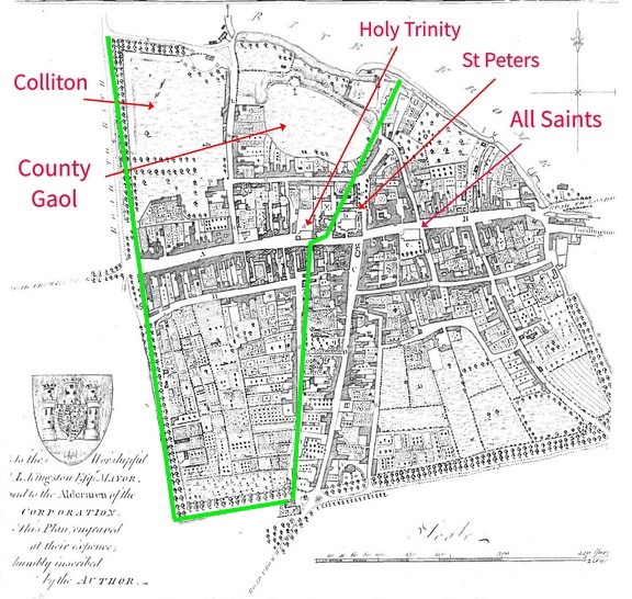
This map appears in the 3rd edition of Hutchins but not the first. It shows Dorchester as it was around 1863. The parish of Holy Trinity was very extensive and in the town included the site of Colliton and the Gaol and everything bounded by the green colour. The area in the left lower quadrant was mostly nurseries and market gardens.
The main function of Dorchester was to service the needs of the rural communities ;
“The agricultural and pastoral character of the people upon whom the town depended for it’s existence was shown by the class of objects displayed in the shop windows. Scythes ,reap-hooks, sheep-shears, bill-hooks, spades, mattocks and hoes at the iron-mongers; bee-hives, butter-firkins, churns, milking stools and pails, hay-rakes, field-flagons, and seed-lips at the cooper’s; cart ropes and plough-harness at the saddlers ; carts, wheel-barrows, and mill-gear at the wheelwright’s and machinists, horse embrocations at the chemist’s; at the glover’s and leather-cutter’s, hedging gloves, thatcher’s knee caps, ploughman’s leggings, villagers patterns and clogs.”
The finances of the various parishes within the town was complicated. According to Hutchins All Saints derived it’s income from “parish lands” but where these were he does not say. In 1722 a private benefactor purchased a small farm in Corscombe called ‘Crockers Moor’ the rent and tithe from which went to support All Saints. When Corscombe was commuted in 1838 however the tithe of Crockers Moor went to the Rector of Corscombe. Other benefactors and Queen Anne’s Bounty appear to have kept the parish afloat.
St Peter’s was, according to Hutchins, worth only £15 when it was ‘instituted’, being dependent on various religious fees and “a moiety of some tithes of gardens in the parish.” It’s support also came from private benefactors and the Queen Anne Bounty. Whatever the tithing arrangement of these parishes neither St Peters or All Saints constituted a tithe district under the TCA and they were not therefore subject to commutation.
Dorchester was surrounded on three sides by Fordington and it fell to the parish of Holy Trinity and Frome Whitfield to cover it’s northern aspect. The tithe map of Holy Trinity is an irregular affair and difficult to describe. It was a large map made up of three sheets of parchment and just below the centre lay the part of the parish that lay in Dorchester itself. This amounted to roughly half of the town. Martin depicts the western part of the borough in detail but the eastern part is only sketchily displayed. Within the western part of the borough there were in fact only fifteen plots that were titheable, the vast majority of the parish been exempt from tithe as they had belonged to the Cistercian Priory that had once been there. Another large area contained ‘Colliton’, nearly nine acres of ‘Mansion House and land’, belonging to the Revd. William Rush Hallett Churchill. He paid a mere 6s rent-charge whilst a nearby house occupying a quarter of an acre was charged 5s. No explanation for the difference is given.
Churchill’s neighbour across the road was the county Gaol, which was tithe free and occupied almost as much land. Over the Frome to the north and east was the tiny village of Frome Whitfield from which extended a massive rectangular tract of land that took in Burton, parts of Charminster but which for the most part contained no more than isolated farmsteads. This large area occupies the right hand side of the map. To the left of the town are a series of lands which are connected to the town by the roads serving them but they are isolated from the town by parts of Fordington. These isolated lands extend out to the boundary with Martin’s Town and there is even an isolated piece of land at Maiden Castle.
The Fordington map to my mind is the more attractive and interesting of the two Dorchester maps. Fordington today is little more than a suburb of Dorchester, but in 1801 it was, in area, bigger than the town itself, whilst its population of two thousand was only a thousand less than Dorchester itself.
The greater part of the Fordington map was drawn at 6 chains to the inch but Martin has an outline plan of part of Dorchester and a detailed plan of the town[as he called it] of Fordington shown as an inset drawn at 3 chains to the inch. The map required three sheets of parchment, for this was a very large parish.
Both sections of the map are attractive and full of interest. Martin’s maps are usually quite crisp in appearance and here he continued to employ a trick that he had used at Chilfrome some 30 years earlier by which the outlines of buildings usually have two edges that are slightest thicker than the other sides. When depicting waterways, such as rivers and streams, he displays the banks by two blue lines with colouring in between. When the water way formed a part of the parish boundary, as on the Fordington map, he coloured the side of the river nearest Fordington a deeper blue. On the Fordington map he delineates the parish boundary by a pale red line.
When it comes to churches it was his custom to depict their shape, or occasionally represent them pictorially, but St George’s Fordington is shown with an extra box around the church to give it greater visual emphasis.

The authors impression of how the Church at Fordington was emphasised.
As at Burton Bradstock where he depicted the Coastguard ‘Preventive’ station in accurate plan view he does the same at Fordington with the Workhouse. Placed at a suitable distance from the town it is a shape that suggests he actually surveyed the house.

The shape of the old workhouse at Fordington. In Martin’s day kept suitably distant from the town being built amidst the open fields.
His bridges on this map are particularly fine, Gray’s Bridge [his spelling] has a 3D effect on the original. By the simple expedient of a

shape on one side, the road appears to have a slight hump as it crosses the river Frome. On the original map the ramparts are depicted so as to show individual stones. Today the area is built up but on the map there is a beautiful tree lined causeway leading out of Dorchester towards Blandford. On his other tithe maps this depiction of the bridges is a variable feature and one senses that here he was trying to impress.
On the large scale section of the map there is a circular area which looks a bit like a circular railway track but is in fact the ‘manor pound and waste’ which belonged to the ‘Parish Hayward for the time being’; the usual way to refer to the transient occupant of an ancient office.
Two ancient monuments, Pummery [now Poundbury] and Maumbury rings are included. Pummery occupied seventy four acres and was used as common pasture. In the apportionment Martin lists each landowners common rights and the rent-charge for the common was based upon these and included in the owners overall charge. In addition to the usual right to graze sheep and cattle, George Henning was, in addition, allowed to graze four horses for general use and more specifically two who were to be worked in the local mill.
Maumbury rings, another neolithic earth works which today is enveloped on two sides by roads, railways and housing, was at isolated in the middle of the open fields. Such was the intensity of the agricultural effort that no respect for it’s antiquity was observed. At nearly an acre in size it was given over to arable cultivation and netted the vicar 2 shillings rent-charge.
On the inset part of the map he depicts the Barracks built in 1794 and the twelve acres of pasture used by the cavalry within the barracks for grazing and training. This was at least tithe free. Nearby was a new housing development, outside of the borough, known as the Grove buildings and amongst which Henry Moule the Rector of Fordington had a chapelry.
More can be said of the map but if you ever get bored you can examine the open field system that is the dominant feature of this map. There are thousand upon thousand strips which are grouped together in seven open fields of various sizes; these are named Castle, Pummery, East, West and Coomb field with on either side of the parish an East and West Ward, the whole taken together, known as Fordington Field. The scale of these fields is truly staggering. The circumference of the parish was about 7 ½ miles and roughly semi-circular and contained conservatively 5 square miles of fields. The modern A35 parallels the shape of the old parish and skirts Dorchester. Joining it at the London Road and leaving at the Martin’s Town roundabout you will have driven about 3.6 miles and had you followed this route in 1840 it would have all been through open fields. They extended to Maiden Castle in the south and to within 400 yards or so of the centre of Dorchester. The whole parish was jam packed with strips. There were so many strips in fact that the plot numbers go up to 2212 and the actual apportionment took up 77 pages.
To my eye the Holy Trinity Map has less artistic detail; Grays bridge for example is depicted on both the Fordington and Holy Trinity Map, but the rendering on the DHT map is frankly less well made. There is no tree lined avenue leading to or from Grays Bridge, and the depictions of the ramparts are cruder. Even stranger is the orientation of the roads. The road that leads to the bridge [today’s B3150] runs through the town of Dorchester in a straight line to the bridge. On the Fordington map the road met the bridge in a straight line in a roughly E direction, as it did in real life; only after crossing the bridge did the road angle, and is still angled, in a NE direction.
Both the original and copy DHT maps demonstrate the same error. The road is not depicted in it’s entire length; it is shown in Dorchester in it’s correct direction and then there is a break before it reappears at the bridge but it does so in the wrong orientation. The road crosses the bridge in a NE direction and continues on in that direction toward Blandford. It is a small point with no direct effect on the apportionment but it is strange that Martin allowed the mistake to stand.
The principle area of interest in the DHT map lies elsewhere. As was common in all open field parishes the selions were grouped in a patchwork of irregularly sized and shaped ‘furlongs’. There were over a hundred furlongs and although none are named on the map they are in the instrument of apportionment.
The names of some furlongs are relevant to our story: Whitewell Bottom, Whitewell Hanging, Bazell, Hall, Spresbury, Lower Slade Hill, Slade, Hamslade, Hamslade Pit, Hamslade Hill, Hamslade Fall, Short Bridge, Nine Acre, Shuffling, Shealds Bottom, Shealds, Shealds Middle, Shealds West, Lawrence Barrow, Pummery Gate, Barn, Lisscomb, Lisscomb Bottom, Acre, Little, Mile Stone and The End furlong all lie to the north of the road to Martin’s town. The milestone is actually shown opposite Acre Furlong. To the south of the Martin’s Town road lay a smaller set of furlongs; Bridport Little, Martin’s Town Path, Drove Pit, Hitching Hedge, Shepherds Barrow. Canton Bars, Ditch End, Morgans Square, Tidden Knap, South Tidden, Tidden Bottom, Tidden Wall, Long Bredy, Twenty acre, Shepherds Bush, Bush Bottom, Windsor Goose and, near Maiden Castle, -Hunting Horn furlong.
To be clear all these furlongs lay in Fordington Field, yet none of them are named on the Fordington map and yet they are all shown on the Holy Trinity map. The result is that large parts of the Holy Trinity map are actually of Fordington parish and the question is: why?
The story of Holy Trinity is derived from Hutchins. At one time a long disappeared hamlet, known as Frome Whitwell, belonged to the parish of Fordington. At some time [he is vague on the point] Frome Whitwell was transferred to the then parish of Frome Whitfield. In 1609 Frome Whitfield, having been “of long time utterly disspeopled [sic]”, and by now without its own church, was annexed to the parish of Holy Trinity by act of Parliament.
The lands of Frome Whitwell, did not of course move to Holy Trinity, they remained firmly in Fordington, but if the land could not move the tithe attaching to it could. Thus it was that the rector of Holy Trinity became entitled to a part of the tithe arising in the parish of Fordington.
How was all this to be displayed on the two maps. This was not an unusual situation and could have been dealt with in several different ways. The most obvious way was simply to ignore the problem and many tithe maps have pieces of land labelled ‘ In xxx parish’. It would then be up to the apportioner of xxx parish to solve the problem.
At Evershot and Frome St Quintin and Abbotsbury, Martin drew separate maps of the disparate parts. At Holy Trinity he could have done what he did, at Child Okeford, which was to inset the outlying areas separately but instead he did something different. He added an extra sheet of parchment to the map and displayed the detached parts of the parish in their correct geographical positions connecting them to each other by the roads which in reality did connect them. The only part of Holy Trinity he could not display in this fashion was at Maiden Castle which had to be inset.
So far so good but there were complicating factors and they are not easy to explain. On the DHT map he plotted forty five of the Fordington Furlongs. Fourteen of these furlongs contained twenty two selions that paid tithe to the Rector of Holy Trinity, the Revd. George Wood. Had these selions all been in one place, as they were at Gobson Common in Child Okeford, they could have been plotted as an inset but unfortunately they were not.
South Tidden Furlong for example was composed of 12 strips but the tithe of just two of these belonged to Holy Trinity. In Lower Slade Furlong there were five strips only one of which belonged to Holy Trinity but it was larger in size than all four of the other strips.
This irregular distribution of these strips must have posed Martin a problem when it came to making the map of Holy Trinity. I suspect that in order to maintain some kind of geographic integrity and shape he found it necessary to copy parts of the Fordington fields onto the Holy Trinity map which paid nothing to Holy Trinity. This would explain the thirty one ‘redundant’ furlongs that served no particular purpose on the DHT map. Rather than copy all of the strips in these redundant furlongs however, he only copied the outline of those furlongs that did not have any Holy Trinity strips in. In those furlongs which did contain Holy Trinity Strips the selions were marked in.
These strips he labelled ‘Loops Land’ and Hutchins notes that Loop’s land belonged to Frome Whitwell at one time. It was probably named after one of the Loop family who were at one time to be found at Wareham and Sherborne. This unusual arrangement is not the end of the story however for the situation was more complex than this.
Reference is now made to the Fordington instrument of apportionment. The parish was commuted by an award made by Aneurin Owen on the basis that the previous seven years tithe did not represent an equitable basis for commutation. The instrument of apportionment details, in schedule 3, the lands lying in Fordington which owed the tithe to Holy Trinity and which amounted to 214 acres. However but the total amount displayed in the furlongs that he plotted on the DHT map amounted to only 66 acres.
In fact the apportionment document for Fordington lists another 88 plots whose tithes were to be paid to Holy Trinity but which were never mapped on the Holy Trinity map. It is true that being scattered these 88 strips would have been difficult to map individually but it is odd that no mention of them is made in the Holy Trinity apportionment which only mentions the 22 ‘Loop Land’ strips.
Being a large parish the rent-charge was over £900 divided between the Vicar, who received £224, a Prebendary of the Cathedral church of Sarum who received £631, whilst the Rector of Holy Trinity, Dorchester got £60.
This kind of division was not unusual; at Stratton the Revd. George Pickard of Warmwell got the bulk of the rent-charge but he did so not because of any clerical duties or responsibilities that he had in Stratton, but in virtue of his role as lay impropriator. What was unusual in the Fordington apportionment was that land that paid tithe to the rector of another parish was mentioned at all, whilst the apportionment of parish to which the tithe should have been paid does not mention them at all.
His work at Fordington must have been particularly profitable as at the same time as the commutation he was working on the Poor’s rate. On February 15th 1844
“At a Vestry held this day pursuant to notice given it unanimously resolved to employ Mr John Martin as a Surveyor to make a Survey of the whole Parish and to make a new Poor rate or assessment accordingly at a charge of £50.
Signed, [amongst others] Henry Moule”
With the commutation work proceeding at the same time it would be another year before the Poor Rate was made and submitted to the Vestry. The next meeting to discuss the matter was held on the 4th July 1845
“At a Vestry Meeting held this day pursuant to notice given for the ‘purpose of appointing competent persons to inspect the new survey of the Parish made by Mr John Martin previous to its being adopted as a Rate or assessment for the relief of the poor’ the following persons were unanimously appointed viz :-
Revd. Henry Moule
Mr William Manfield, Joseph Stone, John Hayne, James Hawkins, Robert Dawson, John Pullidge, Thomas Master, William Slade, George Biles, Joseph Bartlett”
Martin was clearly not impressed as he noted in his diary
| 4th July 1845 | Went to Fordington by desire of the Overseers & attended a Vestry meeting But all there was done at this meeting was the appointment of a committee to examine the Rate Therefore I shall charge £2 2 0 and Expenses |
On August 14th 1845 a further meeting was held of the Vestry,
“At a Vestry Meeting held this day…to notice given resolved to adopt the Poor Rate made by Mr John Martin; and that Mr Yeatman be rated for his tithes in the poors estimated rental at £662 -11-0 and in the rateable value at £465-5-0; the Rev George Wood at £63-0-0 and £45-9-0; and the Rev H Moule at £235-4-0 and £179-4-6; it was also unanimously resolved to allow the Overseer a Rate at one shilling in the pound to meet the expenses of the current quarter.”
On October 16th the vestry met again and set a rate on all houses worth a rental value of £6.
Finally on the 5th February 1846 the vestry record ordered,
“That the Overseers pay Mr John Martins bill for making the Rate amounting to £62 from the rate made this day.”
At the same meeting they had set a rate of 8d in the pound to fund the poor for the coming year.
Thus it was that in this case the Poor Law Commissioners intention to use the tithe map to set the Poor rate was fulfilled. In the following entries there is mention of ‘Rate’ in several of them. With the exception of the first and last entries the relate to the Poor rate.
| 26th June 1845 | Received of Mr John Henning the lt Mr Geo Hennings Fordington Commn Rate £20 4s 6d |
| 24th July 1845 | Attending the Committee at Fordington on the Poor Rate |
| 25th July 1845 | Do and returned Home |
| 26th July 1845 | Completing the Fordington Rate |
| 28th July 1845 | Ruling New Book for the Fordington Rate and working on Child Okeford Award all day |
| 30th July 1845 | Examining Fordington Rate and Okeford Award |
| August 1845 | Received of Mr Sparks his Fordington Commn Rate £4 17 0d |
There is only one diary entry for Holy Trinity. Mr Wood was the rector and I assume Mr Coombs was his agent for he owned no land in the parish. Mr Wood was owed £8 rent-charge on the glebe land rented to William Henning.
| August 1845 | Received of Mr Wood [symbol] Mr Coombs his apportionment expenses for the Holy Trinity Pd into W&D last Wednesday £3 12 0d |
By 1877 changes to the Borough of Dorchester meant that the apportionment of Fordington was time expired. The stimulus was almost certainly the inclosure of the open fields about which I have been able to find no information. In 1299 the manor came to the then ‘Earl’ of Cornwall and subsequently was elevated to a Dukedom and annexed to the lands of the Prince of Wales. It was he probably who ordered the inclosure of the manor and he was amongst those [who included The Burial Board of Dorchester, The Great Western Railway, the London and South Western Railway, The Sanitary Authority of the Borough of Dorchester and numerous individuals] who applied to the Tithe Commissioners for a re-apportionment. The original apportionment of the open fields had run to 77 pages and had some 75 landowners [2]; the new apportionment had just 22 pages and 47 landowners suggesting that it was at this time that the inclosure took place.
Finally what happened to all these churches? Holy Trinity was rebuilt in 1875/6 and then in 1975 the Church of England declared it redundant. 13 months after it was discarded by the Anglicans it was re-opened as a Roman Catholic church. A church had stood on the site since the 11th century and although by 1975 nothing remained of the original Holy Trinity church it may have felt that it had returned to it’s roots after what was after all a short flirtation with Protestantism.
All Saints was also made redundant in 1970 and now forms a store for the Dorset County Museum. St Peters survives as a place of worship in the Anglican tradition but now serves one large parish of Dorchester and West Stafford.
1 He called it Casterbridge. All quotes from the Mayor of Casterbridge.
2 This figure excludes those who occupied houses only.
