|
Parish 32 |
Date of Agreement / Award |
Date of Confirmation of Apportionment |
Sy^mmondsbury |
7/10/1839 |
14/7/1843 |
|
Date on Map |
Scale of Map |
Signatures |
|
None |
6 chains |
John Martin John Symonds |
Yup they got the name wrong; on both maps although interestingly the modern name only has one m in it. This was a large commutation, just 75 acres short of 4000 acres, with a number of centres of population. It is hardly surprising that it was undertaken jointly with another valuer, the eponymously named John Symonds who had in fact no link to the parish or land within it. Being large it was also very profitable; the tithe was commuted for eight hundred pounds. There was nothing unusual about the commutation but the farmers had one of the most expensive moduses 8d / cow in the county.
The Rector, the Reverend Gregory Raymond, had employed Martin previously in 1827,
|
12th March 1827 |
Went to Symondsbury and reced orders from the Revd Mr Raymond to Measure and Map his Estate at Symondsbury |
There was thus a connection with the parish enhanced no doubt by the fact that the Earl of Ilchester owned eight hundred and forty acres in the parish.
The original map has a very flourishing “Bridport Harbour” label outside the harbour entrance and the sea is represented by blue shading which gives a passable impression of waves pounding on the shore. On the left bank of the River Brit at the harbour entrance there is a very narrow and long building, which is not titheable and is almost certainly a rope walk.
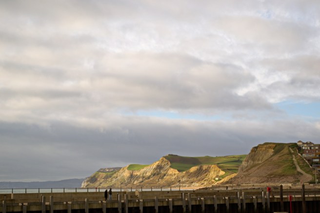
The last cliff on the left is Golden Cap. Although not the highest point in Dorset it is the highest point on the south coast. Below the little hut it the mouth of the Eype. On the far right, now covered with housing is Watton Eweleaze.
The far bank is/was in the parish of Symondsbury. Houses cover Watton Eweleaze and where the blocks of flats are stood a rope walk. In the foreground the land is/was in Burton Bradstock.

Everything to the left of the River Brit was in Symondsbury.
Through the middle of the map runs one of the Queen’s highways – the Great Exeter Road. Leading into the parish the label reads – ‘from Exeter’ and exiting the parish it reads ‘to London’ the only map of his that gives these directions. In an echo of what was to come there was ribbon development of housing along the road. Martin was familiar with the road and in 1810 on his way to Bishopstone he records staying at the Woodyates Inn outside of Salisbury. When regular travel started from London in 1638 the journey to Dorchester cost 30s and took two and a half days and to Exeter four. In 1826 the latest Stage Coaches had got the whole journey down to twenty two hours. Along the road he names a number of hills that could be seen from it but oddly enough the most distinctive, Colmer’s Hill, is not named. Today it’s conical shape still makes it a prominent feature from the road. Along the road can be seen ribbon development of housing.
There are no records from 1838 and although the agreement was reached in 1839 it was not until 1843 that a notice appeared in the Dorset County Chronicle announcing a meeting to read over the draft apportionment. There is no explanation for the delay other than the size of the parish.
|
16th June 1845 |
Received more of Burton Rate £12 7 2d Do of Symondsbury Mrs S Gundry |
I have been unable to trace which Mrs Gundry this was |
|
August 1845 |
Received Mrs Austins Comm Rate Symondsbury £3 8s 0d |
The 1841 census records an Elizabeth Austin whose tithe rent charge was £6 18s 6d. With adjustment for the price of corn this probably represents a half yearly payment. |
|
December 1845 |
Received Sherborne School Symondsbury Rate Com Tithe £3 8s 6d |
The school owned 34 acres in the parish and the rent charge in 1839 was £7 10s 6d. |
