Tithe and inclosure maps were not the only maps to be produced by surveyors and estate maps were probably more commonly produced than indicated by the number that survive or are known about. Two maps relating to Child Okeford were given to the village archivist [not me] in the parish. Both are photocopies but we have no reason to believe that they are not copies of original maps.
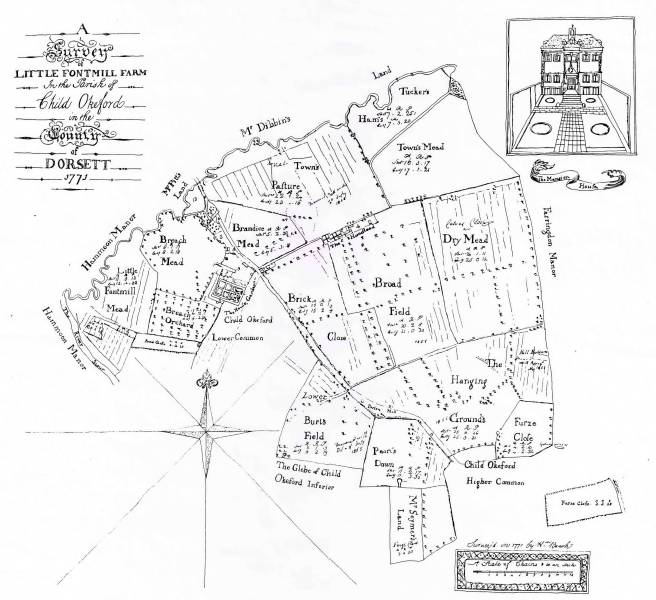
This map is of Fontmell Parva [Little Fontmell] at the northern extremity of Child Okeford. It appears to have been a manor in it’s own right but by the end of the 17th century it became a part of the Trenchard estate [see below] and is interesting for several reasons. It appears rather crudely drawn and is more in the manner of a sketch map than a survey map. The field sizes are given in both customary and statute sizes but it is difficult to determine the relationship between the two. Some of the fields appear to be divided into strips but are probably not indicative of ‘active’ open field farming as they are labelled ‘mead’ or pasture. The house itself is depicted as it was in 1771.

Fontmell Parva House circa 1771
It was eventually bought by a Lieut. Colonel St Loe Malet and over the years a north and south wing were added and it is in this form that it was depicted in the 3rd edition of Hutchins.

Fontmell Parva House as depicted in Hutchins 3rd edition 1865.
If anybody knows anything about tithes it is the maps that were produced as a result of the act. It was a truly impressive effort for twelve thousand seven hundred and thirty three tithe districts were eventually commuted and all had a map annexed to them. The controversy over what type of map was to produced has been covered here . Martin produced no first class maps and the question remains as to how many of his second class maps were produced from new. The answer is in most cases unknowable but in at least one case we can explore the genesis of a tithe map.
Child Okeford had two manors, with the largest belonging to the Trenchard family. In 1826 William Trenchard ordered a survey of his manor known as Child Okeford Superior. The only part of the survey to survive is the book of particulars and naturally enough this does not include the tenures of the other manor in the parish, belonging to the Seymer family [1]. It may be that Seymer ordered a similar survey of is part [Child Okeford Inferior] but if so it has not survived.
Shown below are two crops taken from the survey. The first is of the estate of the Widow of Henry Jenkins. As it happens she owned two estates, one copyhold and the other by leasehold for lives and her name was Sarah. Altogether she owned fifty acres of land across the two estates but the crop that interest us here is no 232 Greenway amounting to almost twelve and three quarter acres.

The widow of Henry Jenkins was in fact called Sarah and she was in posession of two estates in land in the parish. This was a copy hold estate whilst the other was leasehold.
The second crop comes from the estate of Ann Paine who held only fourteen acres and in this case we are interested in plot 233 Lower Stoney lands.

Ann Pain held about fourteen acres together but here we are interested in plot 233 Lower Stoney Land.
Note that the plot numbers for each of the landowners are not sequential; they do not run 1, 2, 3 etc. In an open field system each tenant had numerous strips in different parts of the manor and we would not expect them to do so. What we might expect however is that taking all the tenants of the manor together, the numbers in the survey would run from [say] 1 to 243. Surprisingly this is not seen in the survey the reason being that Child Okeford contained two manors. The missing numbers belonged to the other manor, the survey of which has not survived.
The next document we have to consider was passed to the holder of the village archives in Child Okeford by a villager. It is a black and white copy of a map, that was itself a copy. The villager had found it in the papers of another villager who had died and left them to her. The original map is lost and the quality of the copy is poor. The title tells us that it was made for one of the local farmers, William Wiltshire, in 1834. Wiltshire owned and rented nearly one hundred acres in the parish; we don’t know why he wanted a map of the whole parish.

Photocopy of a photocopy of a map of Child Okeford in 1834. Even the original map was a copy though and we have no idea where the original is or if it even survives.

Surveyed by Wm Jennings Evershot Dorset 18#4 Copied by J Holdway [????] for W J Wiltshire March 6 1834
We now have a survey from 1826, a map of indeterminate date but probably the 1830’s and finally the tithe map with which we can compare details. Doing this we find the following:
- The field names, plot number and area of estates recorded in the 1826 survey correspond exactly with the field names, plot number and area of estates recorded in the Instrument of apportionment of the Tithe survey.
- The plot numbers on the Tithe Map correspond exactly to the plot numbers on the Wiltshire map.
Comparing the Wiltshire map with the tithe map it is clear that they are not precisely identical. The outlying part of the parish known as Gobson Common is in a slightly different place on the page. The orientation of the Wiltshire map is more nearly north than the tithe map and there are subtle differences in the shapes of the roads and field outlines. Nevertheless we are in a position to say the following.
- The 1826 survey of Trenchard’s manor may at one time accompanied by a map but even if not plot numbers and field names recorded were already in existence when the survey was taken and that these numbers and field names were then reused when making the original version of the Wiltshire map and the Tithe map.
- The original version of the Wiltshire map formed the basis of his copy map and the Tithe map.
There is no question that Martin re-drew the Wiltshire map. He had a duty according to Lieut. Dawson “If the plan be of old date, to alter and complete it, so as to represent the true state of the inclosures, and other necessary detail of the parish at the present time; or if plans of portions only of the parish be found, to test and combine them into a plan of the entire parish, adding such further detail as may be required.”
There are no diary entries for the Child Okeford apportionment so we don’t have any clues as to how much surveying Martin did at Child Okeford, but it is possible that he did none at all. Indeed this may have been the case with any number of surveyors and commutations. If there was an old survey available many landowners would probably have been happy to go along with it even if it was not totally accurate. If the land was accurately measured a man might gain a little more land here – but equally might lose a bit more there. Many would doubtless have preferred to let sleeping dogs lie. Besides they might have argued, nothing much has changed around here for decades if not centuries.
Second class maps were never intended to be used as the basis for land registration or legal disputes over boundaries but the Child Okeford one was remarkably durable. In 1906 one hundred and three plots of land in Child Okeford were sold by Claud Berkley Portman to his father William Henry Berkley Portman for the sum of £45,000. An abstract of the title to the lands, whilst it does not include a map of the parish, lists the lands involved in the sale together with their plot number and names. I have only shown two examples but those plots in the 1826 survey that were sold in 1906 bear the same plot numbers and areas. Even the state of cultivation is the same; the only thing to have changed is the invention of the typewriter.


Martin returned to the parish in 1852 to assess the parish for the Poor Rate. Given the enduring quality of the map it would not be a surprise if it formed the basis of the assessment but we have no proof of this.
1There were two manors in Child Okeford the other being owned by the Seymer family. Strangely this survey, undertaken for the William Trenchard, is to be found in the Seymer archive at Dorset History Centre.
Categories: In Depth
